iGotU GPS Tracking Data Logger Review

The i-GotU is a GPS tracking data logger created by Mobile Action. There are two main models under the i-GotU brand, the GT-120 and the GT-600. This review deals specifically with the i-GotU GT-600 and will discuss the main features listed by Mobile Action for this personal tracking device. After that, we will take a look at some of the various applications of this device – several of which will stray from the applications proposed by Mobile Action in their promotional material. This device is not a real time GPS tracking device, so it will only be tested in in data logging activities. Finally, we will take a look at the overall rating given to the device.

i-GotU Review Highlights

  • GPS sensor works great outdoors but looses signal indoors
  • Reading instructions on product operation is a must and does take some time to get used to
  • Sport tracking feature is useful and accurate, but could be better
  • Serves multiple purposes, making it more useful than some devices because of the software package included

Features

The i-GotU comes with the following list of features (taken from the i-GotU website):

Fun & Easy

The i-GotU is relatively easy to use, once you get a basic understanding of what it is you have to do to get it working. As an example, I figured out how to get the basic tracking down after one or two uses but have yet to figure out how to use the motion sensor capability of the device. To turn the device on, simply press and hold the one button on the device until the blue light comes on in the top left hand corner. To turn off the device, press the same button and hold it until the red light appears in the top left hand corner. Simple enough.

But when I follow the instructions printed on the back of the i-GotU packaging for the motion activated tracking feature I was unable to get the device to activate no matter how fast I would go. Here is the picture of the instructions on the packaging:

iGot-U Motion Detector

There must be a setting in the @Trip software that I have to turn on for the device to power on automatically when it senses motion, I just haven’t had the time to search for and figure out exactly what I have to do for it. At the very least, the instructions on how to do this could be improved.

Power Saving

Since I have not been able to activate the motion sensor I am unsure of just how battery saving the device is. I have been able to run the device for 5+ hours without having to charge it while I have been capturing my location at the most frequent rate permitted. Even after running it for 5+ hours I would only plug the device into my computer long enough to download the data to the @Trip software for analysis. I continued this behavior for 3 weeks and have not run out of battery yet, bringing the total amount of tracking to over 16 hours with very little charge time during that 3 week period. Overall the battery life has been pretty impressive.

@trip Service

The @trip service is an online community where you can share your travels, photos, and insights with other iGotU users. I created a profile in all of 1 minute and shared my first trip in less than 20 seconds after that. It is seamlessly integrated with the software that downloads onto your PC and works like a charm. When you share a link with your friends they can view your trip in 3D using a Google Earth plugin – a neat feature if you ask me. The appearance of the trip pages could look better, but it they definitely are a lot nicer than anything I could put together myself. Overall, the @trip service is a nice addition for the traveler who likes to share his adventures with family and friends over the internet.

@trip Software

The @trip Software, which includes the @Trip PC, Sports Analyzer, and Where I Am application, is both useful and feature rich. @Trip PC allows you to log your travels and integrate picture that you took from a digital camera into the journey. It also uploads your trips to the internet very easily. Here is a trip my family took to the zoo where we had the GPS tracking device attached to the stroller: Trip to the Zoo . Most of the pictures were taking at the beginning of the trip since the phone we took them on, an HTC Incredible running the Android OS, was running low on battery.

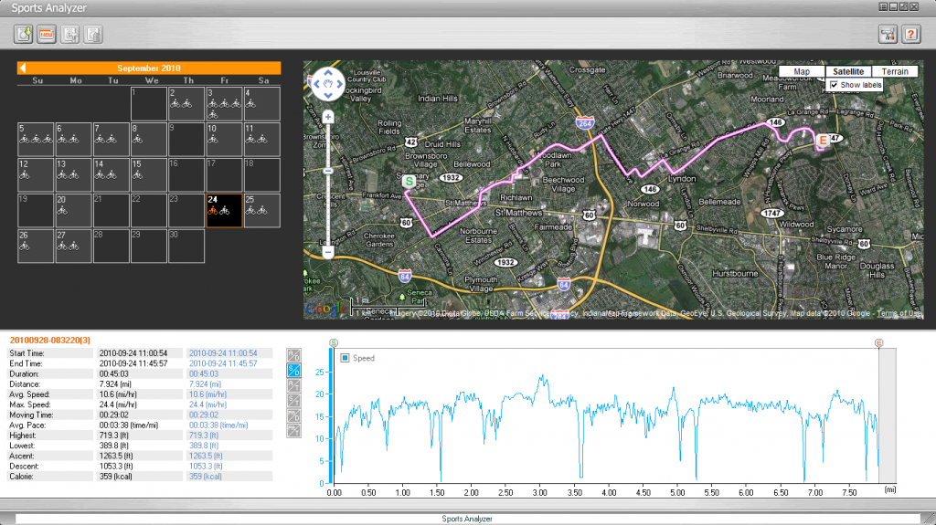
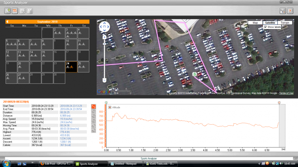
The Sports Analyzer is also very simple to use and easy to understand. The interface is pretty intuitive and the graphs are pretty interesting/helpful for not very serious sports people to understand and analyze. Here is a screen shot of the service:

Sports Analyzer iGotu GT600

Locate & geotag photos

Geotagging photos with the iGotU’s software was a breeze. All I had to do was open the trip and import the folder that had all the photos that I took with my camera. It really was that simple. There is a pretty easy to follow online demo of the process that Mobile Action put together. It can be found here: Photo Locator: Locating my photos easily

The only thing that you want to be sure of is that your digital camera is actually set to the correct time. If you don’t know how to do this on your digital camera I recommend that you pull out your manual and figure it out. I was able to find it pretty easily on my camera, but I know not everyone has the same camera. If you can’t do this, the geotagging feature won’t work because it uses the time stamp on the photo to sync it up with the location that was gathered from the iGotU.

Detect where I am in real time

I have never been able to detect where I am in real time with the iGotU. This is probably because I have always been indoors when trying to use this feature – and the iGotU did not have very good GPS results when indoors. This may service may work great when outside at a cafe or park or some other historic or beautiful destination, but when I was in my home or in class I was not able to find my location.

Record & analyze detailed routes

The iGotU definitely does let you record and analyze detailed routes. In fact, over the course of 3-4 weeks I got to use the device to record my bike commute to and from work in the efforts to see just how detailed and useful the GPS tracking function on this device can be. Overall, I was very impressed with the accuracy of the device and how the information is presented to the user. There were, however, a few drawbacks to the device.

First, lets deal with the short comings. The first is that GPS tracking does not begin immediately upon turning on the device. This is not that big of a deal since all GPS devices have this drawback, but what did make it particularly annoying in this case is that the process could take several minutes. There area few ways to make the cold start less annoying, like holding the device parallel to the open sky, but getting a GPS fix could take anywhere from fifteen seconds to two and a half minutes.

If you do not realize that the device needs to get a fix from the GPS satellites before you start moving you can come to the conclusion that the iGotU personal GPS tracking device is not very accurate. This is a false conclusion, but that is what it will seem like when you analyze your data and get results like this when traveling the same exact route:

DateDistanceTime
9/36.7100:25:56
9/46.6800:23:58
9/56.3400:22:11
9/67.1700:29:53
9/76.6400:23:59

As you can see, for taking the same exact route each day the difference between the distances is pretty extreme. There is almost a mile difference between the shortest and the longest time! This would make any GPS tracking device very innacurate, but in this case there was user error that created the large discrepancy. I simply did not wait for the iGotU to get a fix before starting my journey and got this bad data as a result.

When I waited until the GPS got a fix I got the following results:

00:25:1500:24:01
DateDistanceTime
9/106.87500:23:50
9/116.848
9/126.862
9/136.8500:23:27
9/146.82500:24:06
9/246.98900:24:36
9/256.84400:23:01
9/266.8500:22:50
9/276.86100:23:29

The results of this data represents a much closer grouping of distances given that I take the same route home from work each night. When you take away the reading from 9/24 (6.989 miles) the largest deviation from the average between the various distances in only 141 feet. That seems very accurate to me.

So what about the reading on 9/24? Why is this so different from all the rest?

Here is a picture that explains it all:

9-25 Sports Analyzer Mistake

I did not take my bike on this route when I started the night of the 25th. This is an error in the GPS personal data logger. To me, its not that big of a deal, but to a seriously hardcore mutli-sport lunatic this might make them a little upset.

In my opinion, the iGotU GT-600 is very accurate – it is just prone to wander a little bit.

Share trips & photos on 3D maps

I mentioned this above when talking about the @Trip service, but you can share trips and photos on 3D maps using the service provided by Mobile Action. It is pretty cool and uses Google Earth to display the 3D images for the end user. I think its cool, but each person is going to get their own mileage out of it. You can check out my demo trip here:

Trip to the Zoo

Applications

The iGotU is branded as a personal GP tracking data logger. As such, it has two main functions – to record the places you go on trips and to record the places you go during sporting activities. As a travel logger and personal fitness GPS the iGotU does a decent job, but it is obviously a trip tracker first and a personal fitness GPS second. I still like using if for both, but the sport side of it could use a little beefing up if it is to hold a candle to GPS tracking watches and other sport specific GPSs. But for an all-in-one device the iGotU is pretty solid for both activities. Over the next couple of weeks I plan on putting together some posts highlighting the iGotU’s strengths and weaknesses in the following areas:

Personal GPS Tracking

  • Travel Logger (Full Post Coming Soon)
  • Sports Tracker (Full Post Coming Soon)

Besides the uses discussed by Mobile Action, I wanted to see if I could use the iGotU as a covert GPS tracking device. It is relatively small and could easily be concealed inside a car. Since there is a lot of interest in tracking down a spouse or a teen driver I thought I would put that to the test and see if the iGotU can pass muster. I plan on testing this personal GPS tracker in the following capacity and posting my results here.

Covert GPS Tracking Device

  • Teen Driver Tracking (Full Post Coming Soon)
  • Spouse Tracking (Full Post Coming Soon)

Check back soon for more ways on how to use the iGotU.

Verdict

I would recommend the iGotU to anyone who is interested in a GPS tracking device that allows you to do more than one activity with the same device. The GPS tracking capabilities are solid and the trip sharing software is simple, easy to use, and practically idiot proof. I wish that some of the operations of the device and software were a little more intuitive, but you can get by with some trial and error, looking over the instructions, or watching some of the walk-throughs online. Overall, I think the iGotU is great way to get into the world of personal GPS tracking.
Claim Of Using GPS Tracking To Prank Google Street View Car In Berlin Is Prank

According to F.A.T, Free Art and Technology Lab based out of Germany, they have pranked a Google Street View car by installing a GPS tracking device to it while it was parked outside Haus der Kulturen der Welt in Berlin, Germany. They claim that they were able to somehow attach a tracking device or a GPS cell phone to the car and then receive updates every 2 minutes about the location of the vehicle. They even made a map of the whole think, posting it on their website.

According to some reports, there were even people who used the information displayed on the website to track down the car and perform obscene gestures, shout profanity, or display their private parts in the general direction of the vehicle.

This story has received insane amounts of media attention on the internet and has even gotten a mention of a few TV channels as well, including G4TV:

F.A.T Google Tracking Prank

If one looks carefully at the evidence that is presented on the F.A.T website I think that you will can come to the conclusion that they did not actually track a Google Street View Car with GPS, but instead they merely made a fake one and drove it around like it was from Google and filmed funny and obscene episodes to shame the Internet Giant.

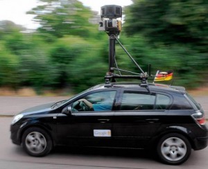
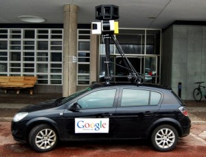
My entire case rests entirely on the their most recent post about how to build a fake Google Street View car. In it, they display the following two pictures (the one on the left is a photo of an actual Google Street View car and the one on the right is of their fake car):

Google Street View Car OriginalGoogle Street View Car Fake
Original Google Street View CarFake Google Street View Car

Let me point out some of the major differences between these two cars – it will become very important later. The first difference is the size of the magnet on the side of the door. The real car has a small magnet while the fake one has a large magnet that takes up most of the door.

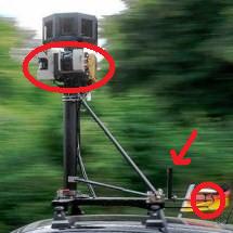
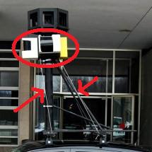
The second, and probably more important difference between the two is the camera and GPS tracking apparatus on the top of the car. I have highlighted some of the differences in the pictures below:

Top of Original Google Street View CarTop of Fake Google Street View Car

Hopefully my skillfully crafted circles and arrows highlight the points of difference enough that I won’t have to spend too much time showing how these are different.

Now here is some footage of the people at F.A.T pranking what they claim to be a Google Street View car. This one is supposedly of a driver drinking while driving:

This is supposedly of a driver picking someone up who is urinating in public:

As you can see in these videos, the car is obviously the fake one created by F.A.T. If the sign on the side of the car is not enough evidence then perhaps taking a closer look at the GPS tracking and camera apparatus located on the top will reveal that it is in fact the fake tracker created by the F.A.T group.

Add to this the information found in this post, Pantless Germans Flash Google Street View Car, and I am led strongly to believe that the whole claim of GPS tracking one of these cars was completely false. I did not include this video because it does have some profanity that could be objectionable to some people, but in the post they say this:

Hot off the press. See also Gizmodo, BuzzFeed, CrunchGear, Reddit, BasicThinking, BoingBoing. Stay tuned for more Google Street View car tracking at fffff.at.

That last sentence seems to indicate to me that they are representing this as video taken from the GPS tracking of the car, when it is obviously not. The video is clearly of the fake car that F.A.T created.

Thus, I think it can be clearly seen that their claim is false and that the claim itself is the actual prank. The videos are made in an attempt to ‘eff Google’ and make them look bad.

If you are interested in learning some more about this group, there is a little blurb from their about page:

The Free Art and Technology Lab is an organization dedicated to enriching the public domain through the research and development of creative technologies and media. The entire FAT network of artists, engineers, scientists, lawyers, musicians and Bornas are committed to supporting open values and the public domain through the use of emerging open licenses, support for open entrepreneurship and the admonishment of secrecy, copyright monopolies and patents.

So in the final analysis it seems like F.A.T. just wanted to make Google look bad and advanced their false claim of GPS tracking a Street View Car in an attempt to bring attention to their cause. I certainly don’t blame them for their attempt, but it is important that we all see what they actually accomplished.

Feel free to check the sources yourself at: Free Art and Technology

Stay Warm and Keep Your Cold Weather GPS Tracker Powered Up

The frosty winds of winter are upon us and what could warm our hearts more than being able to recharge a GPS tracker miles from civilization while giving ourselves a nice little boost in warmth as well?

Well, that is a silly question (obviously) because there are a lot of other things that would warm our hearts much more than that.  Like puppies.  Or sitting down to a meal of Mexican food with Conan O’Brian.  Or the thought of standing way up on the observation deck of the Eiffel Tower and motioning that you want to get down by slithering down the steps like a snake.  All those might warm your heart when stranded and overtaken by the delirium of frost bite.  But if your are getting a warmed heart from one of these things you probably would have benefited from a jacket designed to keep you warm and recharge various electronic devices, including your cold weather GPS tracker.

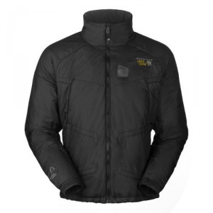
Refugium Cold Weather JacketThe name of this magical jacket is Refugium and it is currently being sold by Mountain Hardware for $230.00 MSRP.  From what I could tell from a quick glance through the online retailers offering this product they were all selling it at a price between $229 and $230.

I have to admit that the name sounds pretty cool to me.  Refugium.  I almost immediately get the image of a wandering individual on a snow encrusted mountain surrounded by silence and the death of winter.  From the looks of things, he stands cold and alone – the enemy of a season that strips the earth bare to make it new again.

But on the inside of his protective shell the man enjoys the warmth of his man-wrought refuge.  A lightweight power source fills his Refugium with warmth derived from countless hours of ingenuity combined with the slow plodding of man into the technological age.

But not only that, his Refugium also keeps a wide variety of his personal electronic devices well charged as well.  Cell phones, MP3 players, digital cameras, and GPS tracking devices all can get some much needed energy love from this mobile power and heating system.

Woah.  Did I just lump GPS tracking devices in the same category as personal electronic devices as mobile phones, iPods, and cameras?  Does that even make any sense?

There are a few good reasons why a GPS tracking device would pair wonderfully with a jacket like this.  The most obvious reason would be that of survival.  Outdoor adventurers usually do not take a break from their adventuring just because there happens to be 4 feet of snow on the mountain.  They still want to do the next big thing.  If they are going to be out in the wilderness for prolonged periods of time chances are they are going to take a GPS tracking device with them, especially if they have friends and family who are concerned for their safety.

And if they are using a tracker it is probably going to be a satellite GPS tracking device since this type of tracker does not rely on a cell phone network to get its location information out to friends and family.  After all, there is not very much cell phone coverage on Mount Whitney, Mount St. Helens, or Mount Everest.  But there is access to the sky, which is home to the satellites used in the GPS system and the commercial communication satellites used  by such tackers as the SPOT GPS tracking device.  If you are a serious outdoorsman whose adventuring takes you far and afield from the hard crust of civilization then a safety device like a satellite tracker is going to be one of your best friends in the event of an emergency.

It might work something this.  An adventurer is out in the midst of the beauty of nature when a storm suddenly approaches.  He is still on the face of the mountain, exposed to the storm as he traverses a particularly treacherous portion of his journey.  The driving snow causes his dangerous journey to become downright perilous as the cold weather begins to attack his footing and the sensation in his extremities.  Blinded by the sheet of white falling steadily, our adventurer misses his next step, falls, and badly injures himself.  After a brief effort to try and find a safe haven to weather out the storm our adventurer resigns himself to endure the rest of the storm in the open and activates his cold weather GPS tracker in the hope that the signal is going to break through the terrible storm that is surrounding him and allow him to contact some rescue personell.  He really does not feel like he had much time since he can feel the warm liquid of his life blood running down his leg.

Unfortunately, the storm is interfering with his GPS’ ability to get a signal from the Global Positioning Satellites as well as the commercial communication satellites that his GPS uses to find its location and to communicate with the authorities.  After a few hours trying to find a trace on his position, the adventurers’ cold weather GPS tracker is beginning to get dangerously low on power.  If his device looses power then it is all over for him as he slowly bleeds to death on the mountain.

Luckily, this is not the end for our GPS adventurer.  He is wearing this Refugium cold weather jacket with its portable power supply.  He docks his GPS into the power supply port and is able to get a few more hours out of his GPS tracking device.  This is just enough time for the storm to dissipate enough for his SPOT GPS tracker to get a strong enough signal to find its location in the world and to make contact with a communications satellite.  The authorities are notified and within a few more hours our adventurer is rescued.

While this is kind of an extreme example, I think it does make the principle extremely clear about how a jacket like this could be used to make GPS tracking last longer in the coldest and harshest of conditions.  It also exmplifies why it might be a better idea for individuals using such a jacket system as they engage in dangerous activities to forgo using it on frivolous items like cell phones (which do will not work in remote areas), iPods, or digital cameras and to instead use it to keep their cold weather GPS tracker alive and active.

New Teen GPS Tracking Devices From Spy Centre Security

Spy Centre Security, a GPS tracking and “spy” device store has announced a new line of GPS tracking devices that they are marketing specifically for parents of teenagers.  According to their press release they have devices starting at $199 the “[make] it possible to get constant updates on your teenagers’ car.”  My initial thought was that if they have a real time teen GPS tracking device for that price then they are going to be pretty competitive in the tracking market.  The only other real time device that I am aware of is the Zoombak and that is retailing right now on Amazon for $125.  Most other real time trackers are going to cost from around $250 and up.

But upon further investigation, it appears that the claims made in the press release are a little misleading.  To those that don’t understand the distinction between a data logger (passive GPS) and a real time tracker (active GPS) could have been duped by the claim made by the following sentence:

At Spycentre.com we now sell GPS products starting at just $199 making it possible to get constant updates on your teenagers’ car.

(While this sentence does come from a site not associated with Spy Centre Security, it does contain their contact information and is very similar to a press release posted on the companies website on September 11, 2009. This leads me to believe that the message is legitimate.)

Consumers need to know the difference between a data logger and a real time tracker if they are to really understand how to best track their teen and to sift through clever marketing attempts of GPS manufacturers.

Teen GPS Tracking Data Loggers

A data logger is a GPS tracking device that simply records the position of the device at set intervals determined by the user or by the device itself.  In order to access the information that the device records, you must retrieve the device and download the contents onto your computer.  GPS tracking software then interacts with the data and plots it on an interactive Google Maps like interface.

Canmore USB GPS Tracking Stick

This type of tracking is great when you only need to know somethings trip after the fact.  For example, if you enjoy launching hobby rockets and you want to know how high and how fast your rocket travels then using a data logger is a great way to get that information.

One of the newest types of data loggers to hit the market are GPS tracking sticks.  These devices are as large as a USB stick and very similar in build and shape.  They even have a male USB connection built in for a simple downloading process.  Just plug the device in and watch the software take over and do the work of analyzing the data for you.

Certainly powerful stuff, but not what most parents think of when they want to know where there teen is. These devices can be great for getting a good understanding of your teen’s driving habits – but they are not good for knowing where your teen is when they are late in getting home. They are not good when a natural disaster strikes and you need to know where your teen is right now. For that, you would need a real time GPS tracker.

With that said, a data logger is what is currently being offered for $199 on the Spy Centre Security website. I wonder how their tracking stick compares with this $145 one from Amazon?

Teen Real Time GPS Tracking

A real time GPS tracking device is one that is able to send its position information from the device to a third party so that the position of the device can be seen in real time.  This is what most parents are going to think about when they are looking into GPS trackers for their teenager.  They are also fairly expensive devices that will end up costing you hundreds of dollars up front and a regular subscription fee for the data transfers between your tracking device and the company’s servers.

The real time trackers available through Spy Centre Security are certainly expensive.  The cheapest models that they offer run $450 and have a service plan of $30 a month according to the press release mentioned above.  The first year of use will run $810 – a steep price to pay for being able to track your teen’s car with GPS.

The Cell Phone Tracking Solution

The obvious solution to this issue is to find a cheaper, real time tracking solution for parents of teenagers.  The best solution that I have come across is to turn a teen’s cell phone into a GPS tracking device.  Many of today’s cell phones already have a GPS antenna inside the phone that allows them to pick up GPS signals from outer space, eliminating the most obvious hurdle off the get go.  And since most teenagers want the latest and greatest cell phone you know that they probably already have a GPS enabled cell phone on them right now.

All that you now need to do is download some GPS tracking software for cell phones and you have a fully functional GPS tracking system in the palm of your teen’s hand.  There are plenty of paid services out there for parents looking at a paid option.  Most cell phone carriers offer something that you can take a look at that will add a nominal monthly fee to your cell bill.

Another option open to parents is to go with free GPS tracking software for cell phones.  This might take a little more work on your part of monitoring and installing the system, but can you beat free?

In the end, whatever you decide to do with your teen is really up to you.  Teen GPS tracking devices are relatively new, but that should not deter parents from taking advantage of this new and powerful technology to help them raise honest, law-abiding children who drive safely and come home on time.  While some might balk at tracking their teen with GPS, here at GPS For Today we feel like there are plenty of reasons why parents have every right to track a teen driver.  If you are interested in reading more about what we have to say on this topic here are some of the more important articles:

GPS Equipped Census Worker Murdered, Is It GPS Tracking Related?

In September a brutal murder occurred that could be related to the government ‘s  stance on marking every residential dwelling in America with a GPS tracking device for the upcoming 2010 census.  [A description of how the body was found is to follow.  It is a little shocking so please only read on if you are interested, otherwise skip to the next paragraph.] The part-time, temporary census worker was found hanging from a tree in a rural Kentucky cemetery.   The body, identified as the remains of a 51 year old cancer survivor Bill Sparkman, was stripped naked by the murder(s) and his hands and feet were bound with duct tape.  His eyes were also duct tapped and his mouth was gagged with something resembling red rag according to the person that reported finding the body.

According to coroner reports, the word “fed” was written on the deceased’s chest.  His census bureau credentials were also taped to his forehead and shoulder area.  These two clues clearly indicate that the murder(s) were either enraged to their despicable deed because he was working with the federal government or that they want the authorities to think that the murder because of his connections with the government.

But what is it about what Mr. Sparkman was doing with the government census bureau that would so fill a person with hate that they would consider murder?

From what I can tell, the deceased, Bill Sparkman, was involved in a push by the government to mark the front door of every residential dwelling in America. While many conservative conspiracy theorists are attacking the current administration over the use of ACORN to do the marking, the actual plan to do so dates back over 2.5 years to no later than July 2006, a time when the Bush administration was still in office.

The idea at the time was to send out temporary staff to gather the exact location of the front door of every residential home in America. This information would be useful to ensure that every household would be counted in the 2010 census, but I am sure that there were additional benefits that the government garner from this move. One of them would certainly be aiding them in identifying tax household that are not reporting information on their tax returns.

It is my guess that this GPS marking activity was what that sent Bill Sparkman out into the Kentucky countryside in September and would eventually lead to his death. I have no way of verifying this information and have not read any reports confirming it – it is simply my guess. If I am right, it might be the first government GPS tracking related death in American history.

My theory goes like this. The deceased was just doing his job going out and marking homes with his GPS tracking device. Part of his instruction was to be relatively extensive in his search of homes – identifying whether or not certain buildings on a property were residential in nature and if someone was living inside them. My guess is that someone took extreme offense at his presence and confronted him about his presences on their property and his use of the GPS tracking unit.

A brief exchange occurred where things got heated and the deceased was attacked. He was then killed for some reason and then his body was dumped in the cemetery as described above.

This would be very sad if true, but I think that just the idea of it warrants a closer look at the use of this GPS information by the government to see if there is any good that can come from it.

Good Government GPS Tracking

We have already discussed what good government GPS tracking implants can do in a previous post, but what about simpler GPS tracking data? Will non real time tracking data also be useful in the hands of the government? The following is a story from NPR from April of 2006 discussing the government’s planned use of GPS to mark all the residential areas in the US. It lists some interesting things that are certainly worthy of consideration.

If the player does not load you can listen or read the story here: Census Bureau Adopts GPS to Find American Homes

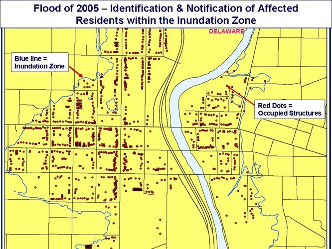
This is the flood map mentioned in the story that the GIS director created with the GPS data that her city had collected:

Government GPS Map Flood Threat

I had never thought of using GPS data in this way, but apparently there are a lot of smart people using this information who can see all the wonderful ways that governments can use this type of GPS to better inform their citizenry about natural disasters. Just think of all the good that would have come of this if it could be used during the wildfire season in Southern California, or in the hurricane season along the gulf coast, or when the Mississippi or one of its tributaries decides to flood. The government could reliably and efficiently notify its citizens about their impending danger, all thanks to the GPS information gathered by a government employee with a hand-held GPS tracking device.

Wouldn’t that be good?

Evil Government GPS Tracking

Then there is the bad that could be done with this type of tracking.  One conservative website [Infowars.com] already mentioned one of them in a recent article from their site.  They write:

The 2% of Americans, who have served military duty at some point in life, are very familiar with the most common use of GPS target painting. The other 98% of Americans might want to pick up a book on the subject, such as The Precision Revolution: GPS and the Future of Aerial Warfare …

The idea is that the government would use the GPS information to wage war against their own citizens.  While this is unlikely that they would fire missiles from planes at our homes (after all, that is a really expensive way to kill one family) it does mean that they can break down your door with some serious accuracy if ever a police state becomes the norm in America.

The government could also sell your information on the open market, a notion that we discussed when examining the bad governments can do with GPS tracking implants.  While this does seem terrible, it almost seems inevitable since the citizens have a right to all the intellectual property that the government creates.  As long as the information isn’t correlated with other information about you that the government has also compiled than that seems less evil than if they did sell the GPS information in that way.

What’s the Verdict?

Is this death GPS tracking related or not?  I certainly don’t know, but it sure seems like it could be.  I personally cannot dream of being so outraged by a census worker’s activity that I would kill them.  Smash up their GPS tracking device – yes.  Intimidate them and scare them off – yes.  Murder them – hell no.  That is just plain wrong and is just as evil as anything that you could think the government would do with your GPS information.  And that is truth you can take to the bank.

Protect Rental Properties With GPS Tracking Devices

When you own a rental property in a remote location you need to find a way to safe guard your investment, especially if you have high value furnishings on your property.  Some owners have turned to installing GPS tracking devices on high value items, such as flat screen TVs, to help reduce the number of thefts as well as to help the police track down their stolen property.

These owners, located in Sevier County, a county in Tennessee which is home to the famous Gatlinburg and Pigeon Forge, came up with the idea to install the GPS trackers after a rash of break-ins swept the county.  One owner reported having over 5% of all his holding broken into over a two or three month period.  Another described having to deal with a break-in every two to three weeks.  The object of these burglaries were flat screen TVs and plasma TVs that were put inside these vacation rentals for use by guests.  Unfortunately, the criminal element realized this and capitalized on the secluded nature of these properties to make off with thousands of dollars worth of merchandise from many cabins scattered across the mountainous terrain.

The problem simply does not end with a stolen TV.  In order to get inside the rental the thief must do considerable damage to the property by busting a window or damaging a door.  This can cost owners $100s or even $1000s in damages – and that is on top of the money that needs to be spent to replace the stolen TV!

There is a relatively low cost solution to these problems: install a real time GPS tracking device onto the items likely to be stolen.  This will help you recover stolen property, reduce the number of thefts on your property, and help you reduce your insurance rates depending on your insurance provider.

GPS Tracking Devices For Theft Recovery

Theft recovery is a well established use of GPS tracking devices.  For this type of tracking you are going to want a device that is going to be able to transmit the coordinates in real time when asked to.  You are not going to want a device that tracks on a continuous basis.  The reason for this is that this type of real time GPS tracking device is going to run out of batteries very quickly and need to have them replaced on a regular basis.  This is fine if you only have 4 or five properties that are all right next to each other, but when you have a 100 or more properties that are spread out over a significant amount of space it would become a  full time job just to make sure all the trackers had enough battery power.

Instead, you are going to want to get a device that only becomes “active” once it is moved.  There are many different models that have this feature so you should have plenty to choose from.  Once the device has been activated it will alert you to its movements and will either send you periodic updates on its position or it will allow you to send the device SMS messages asking for a new position to be sent to your mobile phone.  Once you are certain your device is on the move you can then send the information along to the police who can then arrest the individual and put them being bars.

The following video is a news story that is featured in our GPS tracking videos section that highlights how these devices can be used:

GPS Tracking Devices For Criminal Elimination

The thing about installing a tracker is that you not only recover your stolen property but you also catch a criminal and put them behind bars.  Theoretically, this will lead to a reduction in the number of crimes since the number of people actually engaging in this illegal activity are going to be unable to do it from behind bars.  There is a similar phenomena in GPS tracking bait cars used by police where some cities have seen dramatic reductions in the number of car thefts as the bait cars have seriously cut into the criminal element in the cities.

In addition to eliminating know criminals, it also creates a atmosphere where this type of theft is discouraged.  Remote cabins seem like the perfect place to perform thefts, but when the whole area knows that cabin owners employ remote GPS trackers then they will think twice about doing something stupid on your property.  This means that GPS tracking units promote less crime now and less crime in the future – a win-win-win for the community, law enforcement, and you.

GPS Tracking Devices For Reduced Insurance Premiums

Insurers like to be safe.  If they think that ensuring your property is risky they will end up charging you more for your insurance then you probably want them to.  Also, having regular break ins will also increase your premium, costing you thousands over the course of your policy.  A good way to combat this increased cost is to start using real time tracking devices.  As was mentioned above, this will help reduce the number of break ins and will and help you recover your property which will help keep premiums low. But you also might be able to get a discount with your insurer if they know that you are using a GPS tracking device in your rental property.  Saving money is always great, so why not ask?

\\\///

Protecting your rental properties with GPS tracking devices makes a lot of sense for individuals or companies that are in a region that has a particularly high break in rate.  These devices are becoming increasingly available and are fairly inexpensive for those that are just looking for a real time tracking device that will become “active” upon movement.

Subprime Lenders Get a GPS Tracking Solution Just For Them

Owners of  Buy Here Pay Here (BHPH) car business have a new weapon to lower skips and repossession.  It is a new GPS tracking device from Proconn and it is called The CUBE.  The new, credit card sized tracker is available through Proconn’s subprime automotive finance brand GoldStar GPS.

This technology could not be making it onto the market at a better time, consider the economic climate we are in and this quote from a business owner in the industry, ” … BHPH used car dealers [are] closing their doors all around me….”  Business all around are feeling their profit margins shrink and find themselves needing to run a much tighter ship.  GPS tracking has historically been able to provide this for all sorts of business in types of circumstances.

Why Use GPS Tracking In BHPH?

GPS tracking devices have been proven to be incredibly useful already in several similar applications. Probably the most similar use that I am aware of is in the theft recovery market. In particular, police have been very successful using GPS tracking bait cars to recover vehicles that are specifically designed to get stolen. BHPH GPS tracking works in much the same way.

But what does this doe for a BHPH car business owners? Here are a few benefits:

  • Lower the cost of repossession by saving time – If you know exactly where a vehicle in need of repossession is, you save tons of time in the search process. You can find the car in just minutes and have it towed away in no time at all.
  • Get a grip in your assets management – another major issue that some owners face is having too many cars out and not enough resources to keep track of them all. Once you reach a certain number of vehicles on the road you need some help keeping track of them all and a GPS system is just the thing the doctor ordered.
  • Increase your loan portfolio with less risk – The obvious outcome of the two reasons mentioned above is that you can increase the number of cars that you lend at a reduced risk to yourself and your bottom line. This means that the company can bring in more money, which is always a good thing.

The Cost of The CUBE and GoldStar GPS Tracking

Now the question remains, how much does all this cost? The short answer is that it depends. There is no cost mentioned anywhere on their website and a Google search did not generate any results.

This is to be expected since most business-to-business deals are negotiated. You can certainly contact GoldStar GPS for more information on their pricing structure.

GPS Tracking Features

The CUBE GPS Tracking DeviceWhat is clear on the company’s website are all the features that come with their GPS vehicle monitoring system. Here is a quick run down of some of the feature that this car recovery system sports:

  • Daily Location Report – You will automatically be given the location of the vehicle that you own at least once a day.  This is a “free” location check and will not count against the total number of locates you can make in a given month.  The information is also stored to create a vehicle history so that you can easily get an idea of where the vehicle has been while out of your possession.
  • Stop Report – Another way to get information on your vehicle is to set up stop reporting.  Once a device is no longer in motion for a specified period of time the device will send the location to you so that you can know where the vehicle is making stops.
  • trakSMS™ – This is a wonderful feature for the The CUBE GPS tracking device.  It is a way for a user to remotely control certain aspects of the vehicle’s GPS tracker.  With a simple text message from any text capable cell phone you can find out the speed, direction, and address of the unit as well as have the ability to lock or unlock the doors  and to cut the engine.  How would a person evading repossession like that!
  • Warning Buzzer – This feature lets car owners send a buzz to car users letting them know that a payment is due soon.  If payment is late, dealers can then disable the vehicle.  Fear is a great motivator to get payments in on time.
  • Real-Time Alerts and Notifications – The GoldStar GPS tracking system lets you set up custom alerts that will notify owners of when the car is on the move or whether or not the car has traveled outside one of the six owner generated GeoFences.  This is great when you think a customer may be trying to skip town with your car.
  • State-of-the-Art Mapping and Imaging – This vehicle tracking system utilizes the latest and greatest in GPS tracking software user interfaces.  You can either use Google Earth or Microsoft Virtual Earth to see the units location in a wide variety of views (road map, satellite, or hybrid).

This is a well rounded device that is relatively easy to install and incredibly powerful for business owners looking to improve their profit margins and ensure the safety of their business by keeping tabs on their assets. If you have never though about using a car GPS tracking device for your BHPH car business then now is the time.

Vehicle Tracking Systems Can Save Lives

The power of GPS tracking is truly phenomenal if we let ourselves sit down and think about all the ways it can be used to improve our lives.  But it is not every day that an example of how a vehicle tracking system could save lives comes to the forefront.  On July 26, there was a terrible crash on the Taconic State Parkway in the State of New York that left 8 people, 1 woman and 4 children and three men, dead on their way home from a camping trip. Sadly, the tragedy could have been avoided if there had been an appropriate use of GPS or cell phone technology.

The details of the event are this: one Diane Schuler was driving five children home from a camping trip that sent them to upstate New York. She was experiencing some trouble seeing and had become disoriented (due mainly due to drinking alcohol and smoking marijuana) and made a phone call to her brother to let her know that she was not feeling well. Her brother told her to pull over and let him come and get her. The brother then called the New York State Police to get them to assist them in finding Diane Schuler.

This is exactly the point where a GPS vehicle tracking system would have been the perfect thing to help resolve the situation in a timely manner. If there was such a system installed in the car, perhaps using something provided by by one of the many different GPS tracking device manufacturers, then the brother would then just had to log into the account for the car and get all the details on the location of the vehicle. That would have made his call to the police much more useful. Instead, the police were forced to begin search the Taconic State Parkway in a effort to locate the vehicle being operated by the woman.

Another option other than having a vehicle tracking device installed in the car would be to use the cell phone as a tracking device. Many cell phones can be tracked using one of the many different free GPS tracking software packages made freely available on the Internet. All you have to do is make sure that your cell phone is compatible with the specific system that you are thinking about using, download the software, install it onto your phone, and begin tracking. You’ll want to have a good data plan if you plan on using it for everyday use – but in a situation like this you use it even if you don’t have a good data plan!

Heck, you do not even need a vehicle tracking system or a GPS tracking cell phone. All the lady would have to do is call 911 and stay on the line for a few minutes and the police would be able to have tracked down her location with ease. Even if she had just called and immediately hung up the phone the police would have had a ten mile radius with which to work with in locating her. The longer she stays on the phone the better the location information becomes. But it is pretty obvious why this particular lady did not call 911 – she was drunk and high.

This tragedy puts the use of GPS tracking into perspective. Getting a vehicle tracking system or enabling your cell phone for GPS tracking can be really helpful. For many, getting a vehicle tracking device is going to be cost prohibitive. We simply don’t have the $100s to spend on a system like that. These devices are definitely better suited for GPS fleet management and other commercial applications. And the car tracking devices that are within a normal consumers price range lack some of the features that make them useful for constant use. Since you never really know when a tragedy is going to strike you need a tracking solution that is going to pretty much be on demand. GPS tracking for cars just isn’t up to those levels in their current form.

That is why I am such a fan of cell phone tracking. These device can be used to track a person anywhere they have a cell phone signal, making them great little devices for GPS tracking. There are plenty of free software packages for people to use and we almost always keep them with us and keep them charged. If you want to find a way to get free GPS tracking for cars, then this is definitely the solution that you should be looking for.

Real time GPS vehicle tracking system are invaluable tools in helping us live safer lives. Sure, these tools are so powerful that they can be abused by the wicked and evil, but that doesn’t mean that we should abandon their proper use. I would encourage everyone to set up a vehicle tracking system in case of a roadside emergency – it could be a spare cell phone, your main cell phone, or even a stand along GPS tracking device. Just put one in your car and talk about your plan for using it in the event of an emergency. You’ll be happy you did if you even need it.

Child Tracking With Amber Alert GPS

One of the best devices on the market right now for child tracking is the Amber Alert GPS.  It is a small GPS tracking device than can provide real time updates on your child’s location and help you answer that all important question: where is my child?

With the Amber Alert GPS you get a very powerful GPS tracking device in a nice, compact package. Coming in at 1.77″ x 1.68″ x .78″ this is one of the smaller tracking devices on the market. You can easily conceal this in your child’s pocket, coat, or backpack without it being annoying to the child or easily detectable by someone seeking to do your child harm.

Even though the device is small, it does not loose any of the functionality that parents are going to be looking for in a safety GPS for their child. The position information is accurate and the number of ways that a parent can access this information is impressive. The following are all ways that parents can be alerted about the position of their child:

  • The call or text the Amber Alert GPS to ask for a position update.  If you have a web enabled phone you can see their position on a map right on your phone.
  • View a map of their location online in real time whenever you want to get an update.
  • If your child presses their SOS button you messages can be sent out to 5 phone numbers or emails, meaning that you and your spouse can be notified of the SOS on your phones and your email – this is a great feature for working parents who have to juggle different phone and email accounts.
  • If your child goes outside a predetermined GeoFence then you will be alerted of this movement via text message or email.
  • Be notified if your child starts moving faster than a predetermined speed that you set up.  This can be good for child safety, but is particularly helpful in tracking teen drivers and monitoring their driving behavior.
  • And finally, if the temperature exceeds or drops below a certain threshold there is also an alert that is sent out to you.  This alert can be modified and is useful for ensuring that your child is safe and comfortable.

In addition to all the location feature there are two additional features worth mentioning.  The first is the SOS button.  This button, as you might have implied from the bullet points above, will send out a message containing your child’s location when they press this button.  These messages will continue to appear every 5 minutes, giving you a fresh update of your child’s location.  This is obviously huge.  If your child had to press the button because they were being taken by a stranger then having their position delivered to you every 5 minutes will help you and the police locate your child extremely quickly.  Even if they are not taken, but only injured or scared, it is really nice to be able to get to them quickly if they are on the move without having to call the device to see where they are at.

The second important feature is something that the Amber Alert folks call “monitoring.”  This is a feature controlled by the parent that lets them listen in on what is going on around the child.  Again, this is a huge feature when something is going down with your child and they have pressed the SOS button.  If they are under attack you can hear the voice of the attacker or you can hear that your child is handling the situation appropriately and getting the help that they need.  Monitoring equips you with the knowledge that you need to make an informed decision about your child’s safety.

With all these positives about this child tracking device we have to talk about some of the negatives associated with it as well.  The first is a fairly short battery life.  This device can hold a charge between 18 and 24 hours.  While this is plenty of time in most circumstance, it can be  a hassle to switch batteries every day to ensure your child has full power for the next time they are separated from you.

But to be honest, this power issue is entirely expected.  When you have a device that is as small and concealable as the Amber Alert GPS and allows you to get real time tracking information you are pretty much guaranteed that the battery life is going to be relatively brief.  The technology just isn’t there right now.

If you decide to purchase the Amber Alert GPS  you are going to be getting one of the best products on the market for child tracking.  The device is not cheap, but you really do get a lot for the money that you pay.

How Do GPS Tracking Watches Work?

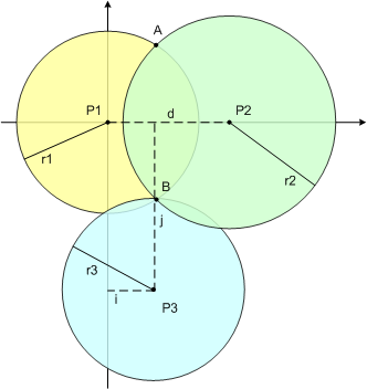
All GPS tracking devices, including GPS tracking watches, work around a few basic geometric principles. These principles are described by the trilateration equation. Trilateration uses the know location of two or more points of reference (the more the better) and the measured distance between the subject and the reference points to give an exact location for the subject. To aid our understanding of this geo-speak, take a look at the two dimensional example below:

GPS Tracking Example

You are standing at point B in this picture (found where all three circles intersect). Let us imagine that you are standing out in the middle of nowhere and you want to find out where ‘here’ is. On your wrist is your GPS tracking watch, ready for instances just like this one. P1, P2, and P3 represent satellites in the NAVSTAR GPS constellation run by the US Government. There are twenty-four of these satellites orbiting approximately 12,600 miles (20,200 km) above the earth surface that are constantly transmitting microwave signals. At the same exact time, these satellites transmit a signal with information concerning their current location and the time that they were transmitted. The colored circles represent the path of the signal from the satellite at a specific time, let us say 8:45:03 AM, August 5, 1991.

Your GPS tracking device is designed to pick up these signals and record the time at which they arrive. Because the signals from the satellites travel at approximately the speed of light, knowing the difference between when the signal was generated and when your watch picks it up will let you know the distance between you and the broadcasting satellite. This is a very simple physics equation (speed x time = distance). When you combine this with the known location of each of the satellites (this information is contained in the signal that your watch picks up) your GPS tracking device has all the information it needs to give you an exact location for where you are.

GPS Tracking Is More Than Trilateration

Your GPS tracking watch will then do something with this new found information. If your watch is a data logger it will simply log your location in its memory and possibly give you a display of your longitude, latitude, and altitude. Data loggers are often simple devices that are used by bikers, hikers, and joggers to record their journeys, track the distances traveled for training purposes, or to build maps or guides if they are exploring new territory. This type of device has many useful applications, but unless you have a map with you in the middle of nowhere (Point B) this type of information will do you no good. If you are every stranded in some nondescript Point B I hope that you don’t have a data logger.

Instead, you want a tracking device that is going to be a data pusher. What these GPS devices do is they transmit their position information at specified intervals to a central database. This database can often be accessed through the internet, providing valuable information to the search party looking for you. Common applications of data pushers include tracking delivery vehicles, locating stolen property (LoJack), or keeping tabs on an object’s or individual’s location. Data pushers are extremely powerful because of the information they provide – but with this power also comes significant risk of abuse. The most common form of data pushing devices are used for GPS tracking are cell phones.

I hope that was a fairly straight forward explanation of how GPS tracking watches work. It was fairly simplified, so if you are interested in finding out more about the complex mechanics I would recommend checking out the following articles:

How To Teach Your Kids About How GPS Works

When teaching your child about their kids GPS, you are going to want to find a way to relate the information in a way that they can understand.  It doesn’t matter what type of GPS you are using with your child – it could be a short range child locator, a GPS tracking watch, or even a covert GPS tracking device – you just need to find a way to give your child a way to wrap their mind around the idea.

A basic understanding of math is always a good thing to have, but if your child is too young to fully grasp things like geometry they might be old enough to measure things.  If you are in this situation, this quick activity may help you out:

  1. Grab a couple of paper plates out of your pantry.
  2. Draw a few satellites in the center of each paper plate.  This will be a great time to explain what a satellite is and how they fly in the sky around the earth.  You can make sure that they know that satellites make up the Global Positioning System (GPS).
  3. Arrange the paper plates so that they resemble the picture found above.
  4. Take out a ruler and measure the distance between each ‘satellite.’ Take the time to explain how this is important for the child locator that they get to use every day.
  5. Now explain that the child locator knows exactly where the satellites are in the sky around the earth.  It can measure where the child is just like you did together with the ruler.
  6. Now take out your cell phone or your child’s GPS kids phone.  Explain that their GPS device for kids works in the same way the phone does – it talks through the air to another phone.  That is exactly what the kids GPS does – it talks through the air to someone else.
  7. And finally, tell them that the person that the GPS tracking watch talks to also talks to Mom and Dad.  That is how you know that the child locator works and why you got it for them.

Most importantly of all, you want your child to fell like they are safe with their GPS tracking watch and that it makes them valuable/special.  This will give them a better understanding of the world that they live in and will enable them to be productive little guys.