When Is Finding a Lost Cell Phone Beyond Hope?

This post is brought to you by real life, my life. Its a story about what happens when a blogger who writes about GPS tracking ends up losing his phone, and how sometimes there is nothing you can do about finding it.

Recently, my family and I were vacationing in America’s Finest City. We were having a great time enjoying the 70 degree weather, the sunny skies, wonderful food, and sandy beaches. The weather was fantastic and a nice break from the frigid January we would have had to spend in the Midwest where we live. We went outside all the time and took several trips to the beach to enjoy the surf, smell the salty air, skip rocks, and get sand everywhere.

Beach Fun 1

We really had a grand ole time.

Beach Fun 2

Beach Fun 3

Then it came time to get back to the car, get the kids clean, and get home. It was clearly nap time. We had to walk a good bit to get back to the car and upon arrival we quickly set about getting the kids ready for departure. While my wife changed one I was cleaning the other – a task made difficult by tiredness and sand’s ability to stick to anything. Frustrated and done it was finally time to get the kids in the car. As I was taking our youngest to his seat I took out my phone to see if I had any messages from friends who I would hang out with later that night. I had none and as I was transferring our child to his car seat I placed my phone on the roof of the car. Big mistake.

Our other child distracted me by wanting me to get him in buckled in too so I went over to his side of the car, got him in, and then got in the car myself. My phone, a Droid X, was still sitting on the top of the car.

We got in the car, popped a U-turn and started heading home. 10 minutes later as the car accelerates up the on ramp to get on the free way we hear a thud and look around the inside of the car to see what had happened. We think its just my son throwing one of his sticks against the side of the car. We continue driving and I think little of the thud and what it could mean.

It wasn’t until we get home, get inside, and lay the napping kids down that I realize I don’t have my phone on me. I panic, but stay calm because I know I have Lookout Mobile Security downloaded to my phone.

I get on the laptop, log into my account, and do a phone locate through their website. It was a long three minutes waiting for the app to tell me where my phone is and at the end of three minutes I still had nothing. So I did it again, hoping that there was just a minor glitch and the phone would figure it out. It didn’t.

Then I downloaded Plan B to my phone, not so much for the location of the phone but to see if it was on and had a network connection. In a lot of our tests in the review of Plan B the app downloaded within a minute to our phone and our GMail account received a message from Lookout telling us it would have a position on our phone soon. This didn’t happen this time.

I found myself in the worst case scenario for loosing your cell phone. My phone was either off, out of batteries, destroyed, or taken over by someone else who knew what to do as soon as they found my phone. At this point there was no technological solution to my problem. All I could do was go back, retrace my steps, and see if I could find my phone. GPS tracking would be of no help to me.

So I got in the car, drove the 20 minutes back to where we parked and surveyed the scene. After looking for a few minutes I faintly remember placing the phone on the roof and then I hear it, the thud as we accelerated onto the freeway. Its at that moment that I realize my phone is not stolen, its not off, and its not out of batteries. My phone is smashed into a confetti of plastic and silicon.

Here are some of my takeaways from this experience:

  1. Sometimes being prepared doesn’t matter. I was certainly prepared in the eventuality that my cell phone might become lost or stolen. I had the necessary apps installed and had done my homework on how to use them. But there are some things that you just can’t control.
  2. GPS tracking apps have their limits. This is really just a restatement of my first takeaway, but needs to be said. Tracking apps ARE NOT the solution for finding every lost phone. Good ole fashioned skills such as retracing your steps and remembering cannot be bypassed.
  3. Don’t be an idiot. I was an idiot and did not properly secure my phone. I should have put it back into my pocket. Or better yet, gotten a magnetic case so it would have stuck to my car. 🙂

iGotU GPS Tracking Data Logger Review

The i-GotU is a GPS tracking data logger created by Mobile Action. There are two main models under the i-GotU brand, the GT-120 and the GT-600. This review deals specifically with the i-GotU GT-600 and will discuss the main features listed by Mobile Action for this personal tracking device. After that, we will take a look at some of the various applications of this device – several of which will stray from the applications proposed by Mobile Action in their promotional material. This device is not a real time GPS tracking device, so it will only be tested in in data logging activities. Finally, we will take a look at the overall rating given to the device.

i-GotU Review Highlights

  • GPS sensor works great outdoors but looses signal indoors
  • Reading instructions on product operation is a must and does take some time to get used to
  • Sport tracking feature is useful and accurate, but could be better
  • Serves multiple purposes, making it more useful than some devices because of the software package included

Features

The i-GotU comes with the following list of features (taken from the i-GotU website):

Fun & Easy

The i-GotU is relatively easy to use, once you get a basic understanding of what it is you have to do to get it working. As an example, I figured out how to get the basic tracking down after one or two uses but have yet to figure out how to use the motion sensor capability of the device. To turn the device on, simply press and hold the one button on the device until the blue light comes on in the top left hand corner. To turn off the device, press the same button and hold it until the red light appears in the top left hand corner. Simple enough.

But when I follow the instructions printed on the back of the i-GotU packaging for the motion activated tracking feature I was unable to get the device to activate no matter how fast I would go. Here is the picture of the instructions on the packaging:

iGot-U Motion Detector

There must be a setting in the @Trip software that I have to turn on for the device to power on automatically when it senses motion, I just haven’t had the time to search for and figure out exactly what I have to do for it. At the very least, the instructions on how to do this could be improved.

Power Saving

Since I have not been able to activate the motion sensor I am unsure of just how battery saving the device is. I have been able to run the device for 5+ hours without having to charge it while I have been capturing my location at the most frequent rate permitted. Even after running it for 5+ hours I would only plug the device into my computer long enough to download the data to the @Trip software for analysis. I continued this behavior for 3 weeks and have not run out of battery yet, bringing the total amount of tracking to over 16 hours with very little charge time during that 3 week period. Overall the battery life has been pretty impressive.

@trip Service

The @trip service is an online community where you can share your travels, photos, and insights with other iGotU users. I created a profile in all of 1 minute and shared my first trip in less than 20 seconds after that. It is seamlessly integrated with the software that downloads onto your PC and works like a charm. When you share a link with your friends they can view your trip in 3D using a Google Earth plugin – a neat feature if you ask me. The appearance of the trip pages could look better, but it they definitely are a lot nicer than anything I could put together myself. Overall, the @trip service is a nice addition for the traveler who likes to share his adventures with family and friends over the internet.

@trip Software

The @trip Software, which includes the @Trip PC, Sports Analyzer, and Where I Am application, is both useful and feature rich. @Trip PC allows you to log your travels and integrate picture that you took from a digital camera into the journey. It also uploads your trips to the internet very easily. Here is a trip my family took to the zoo where we had the GPS tracking device attached to the stroller: Trip to the Zoo . Most of the pictures were taking at the beginning of the trip since the phone we took them on, an HTC Incredible running the Android OS, was running low on battery.

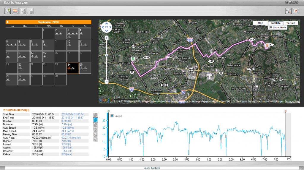
The Sports Analyzer is also very simple to use and easy to understand. The interface is pretty intuitive and the graphs are pretty interesting/helpful for not very serious sports people to understand and analyze. Here is a screen shot of the service:

Sports Analyzer iGotu GT600

Locate & geotag photos

Geotagging photos with the iGotU’s software was a breeze. All I had to do was open the trip and import the folder that had all the photos that I took with my camera. It really was that simple. There is a pretty easy to follow online demo of the process that Mobile Action put together. It can be found here: Photo Locator: Locating my photos easily

The only thing that you want to be sure of is that your digital camera is actually set to the correct time. If you don’t know how to do this on your digital camera I recommend that you pull out your manual and figure it out. I was able to find it pretty easily on my camera, but I know not everyone has the same camera. If you can’t do this, the geotagging feature won’t work because it uses the time stamp on the photo to sync it up with the location that was gathered from the iGotU.

Detect where I am in real time

I have never been able to detect where I am in real time with the iGotU. This is probably because I have always been indoors when trying to use this feature – and the iGotU did not have very good GPS results when indoors. This may service may work great when outside at a cafe or park or some other historic or beautiful destination, but when I was in my home or in class I was not able to find my location.

Record & analyze detailed routes

The iGotU definitely does let you record and analyze detailed routes. In fact, over the course of 3-4 weeks I got to use the device to record my bike commute to and from work in the efforts to see just how detailed and useful the GPS tracking function on this device can be. Overall, I was very impressed with the accuracy of the device and how the information is presented to the user. There were, however, a few drawbacks to the device.

First, lets deal with the short comings. The first is that GPS tracking does not begin immediately upon turning on the device. This is not that big of a deal since all GPS devices have this drawback, but what did make it particularly annoying in this case is that the process could take several minutes. There area few ways to make the cold start less annoying, like holding the device parallel to the open sky, but getting a GPS fix could take anywhere from fifteen seconds to two and a half minutes.

If you do not realize that the device needs to get a fix from the GPS satellites before you start moving you can come to the conclusion that the iGotU personal GPS tracking device is not very accurate. This is a false conclusion, but that is what it will seem like when you analyze your data and get results like this when traveling the same exact route:

DateDistanceTime
9/36.7100:25:56
9/46.6800:23:58
9/56.3400:22:11
9/67.1700:29:53
9/76.6400:23:59

As you can see, for taking the same exact route each day the difference between the distances is pretty extreme. There is almost a mile difference between the shortest and the longest time! This would make any GPS tracking device very innacurate, but in this case there was user error that created the large discrepancy. I simply did not wait for the iGotU to get a fix before starting my journey and got this bad data as a result.

When I waited until the GPS got a fix I got the following results:

00:25:1500:24:01
DateDistanceTime
9/106.87500:23:50
9/116.848
9/126.862
9/136.8500:23:27
9/146.82500:24:06
9/246.98900:24:36
9/256.84400:23:01
9/266.8500:22:50
9/276.86100:23:29

The results of this data represents a much closer grouping of distances given that I take the same route home from work each night. When you take away the reading from 9/24 (6.989 miles) the largest deviation from the average between the various distances in only 141 feet. That seems very accurate to me.

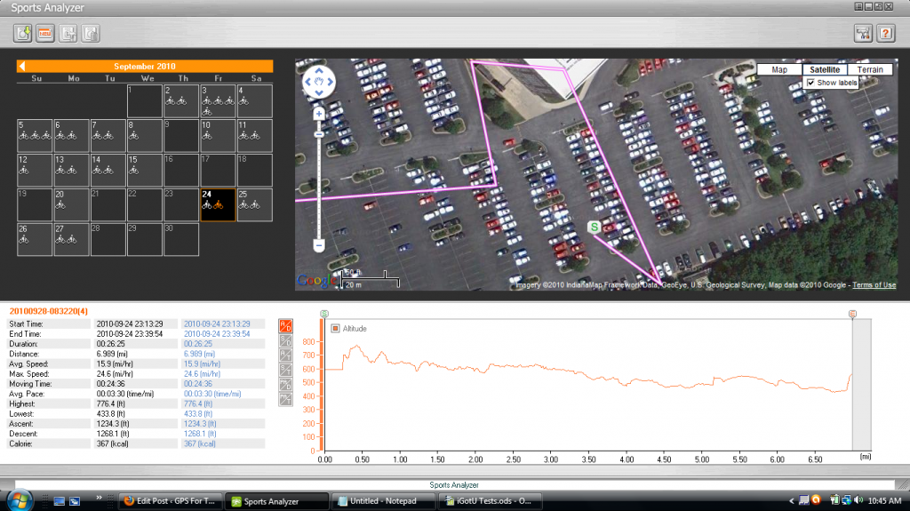
So what about the reading on 9/24? Why is this so different from all the rest?

Here is a picture that explains it all:

9-25 Sports Analyzer Mistake

I did not take my bike on this route when I started the night of the 25th. This is an error in the GPS personal data logger. To me, its not that big of a deal, but to a seriously hardcore mutli-sport lunatic this might make them a little upset.

In my opinion, the iGotU GT-600 is very accurate – it is just prone to wander a little bit.

Share trips & photos on 3D maps

I mentioned this above when talking about the @Trip service, but you can share trips and photos on 3D maps using the service provided by Mobile Action. It is pretty cool and uses Google Earth to display the 3D images for the end user. I think its cool, but each person is going to get their own mileage out of it. You can check out my demo trip here:

Trip to the Zoo

Applications

The iGotU is branded as a personal GP tracking data logger. As such, it has two main functions – to record the places you go on trips and to record the places you go during sporting activities. As a travel logger and personal fitness GPS the iGotU does a decent job, but it is obviously a trip tracker first and a personal fitness GPS second. I still like using if for both, but the sport side of it could use a little beefing up if it is to hold a candle to GPS tracking watches and other sport specific GPSs. But for an all-in-one device the iGotU is pretty solid for both activities. Over the next couple of weeks I plan on putting together some posts highlighting the iGotU’s strengths and weaknesses in the following areas:

Personal GPS Tracking

  • Travel Logger (Full Post Coming Soon)
  • Sports Tracker (Full Post Coming Soon)

Besides the uses discussed by Mobile Action, I wanted to see if I could use the iGotU as a covert GPS tracking device. It is relatively small and could easily be concealed inside a car. Since there is a lot of interest in tracking down a spouse or a teen driver I thought I would put that to the test and see if the iGotU can pass muster. I plan on testing this personal GPS tracker in the following capacity and posting my results here.

Covert GPS Tracking Device

  • Teen Driver Tracking (Full Post Coming Soon)
  • Spouse Tracking (Full Post Coming Soon)

Check back soon for more ways on how to use the iGotU.

Verdict

I would recommend the iGotU to anyone who is interested in a GPS tracking device that allows you to do more than one activity with the same device. The GPS tracking capabilities are solid and the trip sharing software is simple, easy to use, and practically idiot proof. I wish that some of the operations of the device and software were a little more intuitive, but you can get by with some trial and error, looking over the instructions, or watching some of the walk-throughs online. Overall, I think the iGotU is great way to get into the world of personal GPS tracking.

GPS Navigation For Cyclists With The iPhone

Wild and crazy Zeptotools has come up with an ingenious way to incorporate an iPhone’s GPS navigation application and an HMD display with the act of riding a bicycle, creating the first cell phone based bicycle navigation system that I am aware of.   They call this system ARider.

While there are many, many detractors of this system – the folks over at Zeptotools do deserve some credit for putting together a prototype of their idea even if it doesn’t prove to be commercially viable.  One has to admit that what they have done in combining these technologies together is just plain cool and that the world of cell phone navigation, GPS tracking applications, and the iPhone will never be the same.

Zeptotools is an iPhone app developer who has created some very slick, very interesting applications. There current applications include ZeptoPad, ZeptoLiner, IRCon, iShodo, BullCam, Quick Pigeon, and Montblanc Pen. The short video to the right gives a really good impression with the type of stuff that these guys are putting out. Everything about it, the music, the cinematography, and even the way the people are dressed gives you all you need to know to understand what these guys are about. Cool stuff. Chic. Web 2.0. Etc.

ARider does not stray from this feel.  While still in the prototype phase, the design is sleek and appealing.  And even though they use Scotch tape to attach the HMD to the bike helmet it still looks really cool.  Here is a video of the GPS system in action to give a little flavor of what this device actually looks like.  It was put together by the folks at Zeptotools so you know it is going to have a cool music score (which it does).  So here it is:

Pretty cool if you ask me. A working prototype for cycling GPS navigation.

The Detractors

With anything so visionary you are going to get people who want to hate on it. The ARider GPS navigation system is no different. Just take a look at some of these comments about this revolutionary GPS tracking mapping device:

Putting your expensive smart phone on top of your bike helmet seems like a good way to destroy it and possibly yourself too, if you get into an accident, which is in turn made more likely by adding distracting displays to your field of view.

And this one:

Dangerous to your expensive iPhone and useless. The only way this would be slightly useful is if you were in a new, unfamiliar city. Urban cyclists, after a year or so of riding, don’t need a map to tell them how to get around their city. In fact, most of the pertinent information to cycling isn’t on any map, let alone Google. Isn’t cycling wonderful because of the freedom? Why would we want to make it more car-like and stick a HMD in front of us?

And another:

As a cyclist, I must say this is a great way to get badly injured while cycling. It’s bad enough to text while driving, but to be distracted on a bike is insanity.

This pretty much sums up the voices of dissent who are too short sighted to see just how cool this thing is. As a regular bike commuter I think that this devices is incredibly cool and could be extremely useful for a whole host of applications, not just GPS navigation related.

ARider and GPS Tracking

One of the coolest things about this application is that it offers an augmented reality.  Apache helicopter pilots experience the same sort of thing when they pilot their helicopter.  The main machine gun mounted on the underside of the helicopter is controlled by the turning of the head of the gunner.  His vision is completely augmented by his helmet and it does take a lot of training to get used to the effect that this has one’s vision.  But that doesn’t mean that this is bad.

For example, not military personnel say, “That sure seems like a good way to crash a multi-million dollar helicopter and waste all the man hours we spent training that pilot.”  That is just silly.  The fact is that augmented reality is powerful and useful tool for incorporating electronic inputs into our realm of experience.

Bionic Eye GPS TrackingI can imagine something like this but use it in relation to people.  Bionic Eye, an iPhone app, already augments reality with business locations.  What would prevent someone creating an application that works together with a GPS tracking application that will give you an idea of where actual people are in your field of vision?  Now that would be fun, useful, and interesting to use.

You could always know where friends and family are at any given moment with the aid of GPS and an augmented reality.  All you would have to do is look in their general direction and you could get a really cool visual of exactly where they are in relation to you just the photo to the right suggests.

The applications for this technology would be robust.  How easy would it be to keep your kids safe in a theme park if you could get a visual idea of how far away they were at any given moment?  You wouldn’t panic if your child gets lost in a crowd or is briefly separated from you.  All you would need to do is use your GPS tracking augmented reality to come up with an idea of where they are at.

The same is true for Alzheimer suffers, teen drivers, spouses, friends, important assets, and the list goes on and on.

So I think that the work by the folks at Zeptotools is really, really cool and could impact not only the world of GPS navigation for cyclists, but also impact how people begin to interact with their position in a way that is currently only being utilized by the military.  Once GPS tracking augmented reality feasible in the day to day of life I think that it will catch on like wildfire and change the face of GPS tracking forever.

Zeptotools: http://zeptotools.com/

GPS Tracking For Real Estate Agents and Prospective Home Buyers

If you are prospective home buyer or a real estate agent who wants to get on the fly, real time house price data then you might want to check out Smarter Agent, a GPS tracking application for real estate prices on your cell phone.  There are several products that Smarter Agent offers that couples the power of GPS position data with the public record information that would be very useful for home buyers and real estate agents alike.  It appears that the application has both free and paid components, letting you give the service a shot before you upgrade to one of the different paid services.

Free Real Estate GPS Tracking Services

From what I can tell from the website and my own playing around, you can get the Homes For Sale cell phone application for free from their website.  This software will turn your GPS-enabled cell phone into a powerful home finding tool.  All you need to do is install the software onto your phone and then take it with you to the neighborhood that you would like to buy a home in. With just the press of a single button you will have a map display of your location and the location of the 10 nearest homes for sale around you.  Users can zoom the map in or zoom the map out so they can get a tighter or wider view of the listing and surrounding area.  If you want to see more information about the home then just scroll to and take a look.

If you would prefer to see things as a list, this free GPS cell phone application lets you you do just that.  It lets you see the top 10 properties that are the closest to the exact location where you are standing according to the cell’s GPS tracking chip.  The list view allows you to view property details, plot results on a map, save your search, or expand it to see additional properties in your vicinity. There is even the ability to save your search if you thought that the listings were particularly important to your home search.

Smarter Agent’s Homes For Sale also displays some detailed information about each listing if you want to give that a look.  You can see such things at the house’s address, the sale price, the number of beds and bathrooms, the square footage of the home, the estimated mortgage given certain parameters like interest rate and down payment, and the taxes that the home owner pays when that information is available.  This information can be huge for those that are just getting acquainted with an area and want find out where some of the houses for sale are located.

In all, this is a great way for people looking for a solid GPS real estate application to get their feet wet for free.

Paid Real Estate GPS Tracking Services

The main reason that Smarter Agent is offering their Homes for Sale application for free is that they are hoping that people will buy their premium product, Recently Sold Homes. For $4.99 a month you can have access to information about the closest homes sold within the last three years.  The information available from this GPS application includes the last sold price for homes nearby, the last sold date, and the square footage of the home sold.  As you can imagine, this can be very helpful information for getting an understanding of how competitively prices some of the current homes for sale are.

While this information is not going to be incredibly precise, it is still helpful for those that are new to a region to get an idea of what is going on in a region’s real estate market.  If you are just starting out with a real estate search then you might want to consider getting your GPS tracking cell phone out and installing Homes For Sale.  If you like the way it works and are particularly interested in homes in a certain area then you might want to buy the Recently Sold Homes application as well.  The $4.99 might save you some considerable time in your searches.

Compatible Sprint GPS Cell Phones

Homes for Sale is available on the following Sprint mobile phones:

  • Blackberry Curve 8300
  • Blackberry 8800 World Phone
  • Blackberry Pearl
  • Blackberry Tour
  • LG 535
  • LG LX 550 Fusic
  • LG LX570 Muziq
  • LG lx400
  • LG Lotus
  • LG Rumor
  • Motorola KRZR K1m
  • Motorola RAZR V3m
  • Motorola SLVR L7c
  • Motorola RAZR2 V9m
  • Palm Pre
  • Samsung A900
  • Samsung A920
  • Samsung M500
  • Sanyo Pro200
  • Samsung M610
  • Samsung M620 UPSTAGE
  • Samsung A727
  • Samsung M520
  • Samsung Instinct
  • Samsung Rant
  • Samsung S30
  • Sanyo 6600 Katana
  • Sanyo 7400
  • Sanyo 7500
  • Sanyo 6650 Katana 2
  • Sanyo 8500 Katana DLX
  • Sanyo 8300
  • Sanyo 8400
  • Sanyo M1
  • Sanyo 7050
  • Sanyo Pro700

Compatible AT&T GPS Cell Phones

Homes for Sale is available on the following Sprint mobile phones:

  • Apple iPhone
  • Blackberry 8100 Pearl
  • Blackberry 8300 Curve
  • Blackberry 8800 World Phone
  • Blackberry 9000 Bold
  • Blackberry Pearl
  • LG CU400
  • LG CU500
  • LG CU575 Trax
  • LG CU515
  • LG CU720 Shine
  • Motorola KRZR
  • Motorola SLVR L6
  • Motorola SLVR L7
  • Motorola RAZR V3
  • Motorola v365
  • Motorola RAZR2 V9
  • Motorola V3xx
  • Nokia 6085
  • Nokia 6555
  • Samsung A437
  • Samsung A707
  • Samsung A717
  • Samsung D407
  • Sony w300i
  • Sony w580i
  • Sony w810i

\\\///

GPS tracking is becoming more and more important for cell phone users as more and more applications are becoming available that allow users interact with the world around them in such a way that they get what they want, when they want it, and where they want to get it.  We are becoming a mobile society, GPS and cell phone technology are giving use everything we could every want when it comes to have relevant, location-based information in real time.

Subprime Lenders Get a GPS Tracking Solution Just For Them

Owners of  Buy Here Pay Here (BHPH) car business have a new weapon to lower skips and repossession.  It is a new GPS tracking device from Proconn and it is called The CUBE.  The new, credit card sized tracker is available through Proconn’s subprime automotive finance brand GoldStar GPS.

This technology could not be making it onto the market at a better time, consider the economic climate we are in and this quote from a business owner in the industry, ” … BHPH used car dealers [are] closing their doors all around me….”  Business all around are feeling their profit margins shrink and find themselves needing to run a much tighter ship.  GPS tracking has historically been able to provide this for all sorts of business in types of circumstances.

Why Use GPS Tracking In BHPH?

GPS tracking devices have been proven to be incredibly useful already in several similar applications. Probably the most similar use that I am aware of is in the theft recovery market. In particular, police have been very successful using GPS tracking bait cars to recover vehicles that are specifically designed to get stolen. BHPH GPS tracking works in much the same way.

But what does this doe for a BHPH car business owners? Here are a few benefits:

  • Lower the cost of repossession by saving time – If you know exactly where a vehicle in need of repossession is, you save tons of time in the search process. You can find the car in just minutes and have it towed away in no time at all.
  • Get a grip in your assets management – another major issue that some owners face is having too many cars out and not enough resources to keep track of them all. Once you reach a certain number of vehicles on the road you need some help keeping track of them all and a GPS system is just the thing the doctor ordered.
  • Increase your loan portfolio with less risk – The obvious outcome of the two reasons mentioned above is that you can increase the number of cars that you lend at a reduced risk to yourself and your bottom line. This means that the company can bring in more money, which is always a good thing.

The Cost of The CUBE and GoldStar GPS Tracking

Now the question remains, how much does all this cost? The short answer is that it depends. There is no cost mentioned anywhere on their website and a Google search did not generate any results.

This is to be expected since most business-to-business deals are negotiated. You can certainly contact GoldStar GPS for more information on their pricing structure.

GPS Tracking Features

The CUBE GPS Tracking DeviceWhat is clear on the company’s website are all the features that come with their GPS vehicle monitoring system. Here is a quick run down of some of the feature that this car recovery system sports:

  • Daily Location Report – You will automatically be given the location of the vehicle that you own at least once a day.  This is a “free” location check and will not count against the total number of locates you can make in a given month.  The information is also stored to create a vehicle history so that you can easily get an idea of where the vehicle has been while out of your possession.
  • Stop Report – Another way to get information on your vehicle is to set up stop reporting.  Once a device is no longer in motion for a specified period of time the device will send the location to you so that you can know where the vehicle is making stops.
  • trakSMS™ – This is a wonderful feature for the The CUBE GPS tracking device.  It is a way for a user to remotely control certain aspects of the vehicle’s GPS tracker.  With a simple text message from any text capable cell phone you can find out the speed, direction, and address of the unit as well as have the ability to lock or unlock the doors  and to cut the engine.  How would a person evading repossession like that!
  • Warning Buzzer – This feature lets car owners send a buzz to car users letting them know that a payment is due soon.  If payment is late, dealers can then disable the vehicle.  Fear is a great motivator to get payments in on time.
  • Real-Time Alerts and Notifications – The GoldStar GPS tracking system lets you set up custom alerts that will notify owners of when the car is on the move or whether or not the car has traveled outside one of the six owner generated GeoFences.  This is great when you think a customer may be trying to skip town with your car.
  • State-of-the-Art Mapping and Imaging – This vehicle tracking system utilizes the latest and greatest in GPS tracking software user interfaces.  You can either use Google Earth or Microsoft Virtual Earth to see the units location in a wide variety of views (road map, satellite, or hybrid).

This is a well rounded device that is relatively easy to install and incredibly powerful for business owners looking to improve their profit margins and ensure the safety of their business by keeping tabs on their assets. If you have never though about using a car GPS tracking device for your BHPH car business then now is the time.

Elderly Man Saved By SPOT GPS Tracker

One elderly man is very happy that his son had his SPOT GPS tracker with him when an ATV accident on an annual hunting trip left him unconscious and bleeding from the head.  The accident, which occurred in August this year, came just two days after the unique tracking device was active by his son.

The SPOT GPS tracker is a stand alone real time GPS tracking device that works in a way different from most tracking devices.  Instead of relying upon a cellular network to get its position data out so that it can be tracked it uses commercial satellites to relay this data to interested parties.

It is also specifically designed for outdoor enthusiasts who get away from civilization and cell phone signals.  It has a specially designed 9-1-1 button that will notify local rescue authorities that you are having an emergency and that you need assistance.  You can imagine how useful this feature is for people who in need of assistance when they are miles away from civilization.

Clarence Kolcun was 8 km away from base camp when he lost control of his ATV and rolled the vehicle on top of himself. When his son, Gordon, got to the scene of the accident his father was unconscious and bleeding from the head. Unable to adequately treat his father, he woke him up and drove the 8 km back to the base camp to retrieve the SPOT GPS tracker so that he could activate the 9-1-1 feature.

Twenty minutes after the 9-1-1 button was pushed, the Kolcun family was contacted by search and rescue authorities who inquired about the details of the men using the tracking device as well as some other identifying information like the make and model of their vehicle and the color of their ATVs.

This is by and large the strongest selling point for this type of GPS tracking unit.  Being able to mobilize help in such a short time span is paramount in being able to survive an accident. Clarence was unable to move and could sense that he suffered from internal injuries.  If there was no SPOT GPS tracker then help would have arrived much later than it eventually did.

As you might expect, the emergency personnel were able to locate the injured man and his companion and they were air lifted out of the bush so that the injuries of the injured could be treated.

SPOT GPS Tracker: SOS Device

This device is absolutely fantastic as an SOS GPS tracker.  Because it does not rely on cell phone signals it is able to work in a wide variety of circumstances that would not normally be possible with conventional tracking units.  This story is just one of the many different situations where a product of this nature did save the life of hunter, hiker, climber, or camper – and it certainly won’t be the last.

While these type of devices are certainly not perfect, they do provide a level of safety for outdoor adventurers that is unparalleled by any other device out on the market.  Just take a look at the coverage that this device enjoys:

SPOT GPS Tracker Coverage Map

This means that if you are on an adventure in Australia and you find yourself lost and stranded in the Outback without water and food all you need to do is press your 9-1-1 SOS button and you are going to know that the authorities are going to be notified of your need and given your GPS coordinates sot that they can find you and provide the help that you need.

This type of GPS tracking system is certainly not cheap.  As you can see, the device itself costs around $100 – but that is not the end of the cost associated with this device.  For 1 year of basic service you are going to have to pony up another $100.  While this may seem like a lot right now, I am sure that when something catastrophic happens then it will seem like nothing!

When it comes down to it, the vast majority of people are not going to need a device like this.  Thousands upon thousands of people go out into the wilderness each year and come home without incident.  They simply do not need a GPS device that tracks their movements and alerts family members of their whereabouts.  It is superfluous for these people.

But then every year there are dozens upon dozens of individuals or groups that could definitely benefit from this type of tracking capability.  They have a very serious injury in their party and the difference between life and death can only be a matter of minutes.  It is for these people that the SPOT Satellite GPS Messenger are some important for.

Who will these people be?  If you have an elderly person in your hunting or camping party, it could be you.  Or if you have young children on your back packing trip, it could be you.  If you have a first time climber going up the mountain with you, it could be you.  If you attempting a dangerous route, it could be you.  The thing is, it could be any of us at any moment.  We just never know when a stray rock is going to slide off a mountain and strike one of our companions, or a wild animal decide to attack, or a freak weather phenomena blows away all your gear.  Anyone could need the help of a SOS GPS tracker.

That is why we need to walk with out eyes open when we make these types of trips out into the wilderness.  If we have weighed our options and decided that we don’t need the assistance of a GPS tracking device to give us the extra sense of security then we should not buy one.  But when we want that little extra comfort of knowing that help is only a button away – that is when getting a SPOT GPS tracker is the right move.

How To Use GPS Real Time Tracking Effectively

Here is a quick little story ripped from the headlines about the effective use of GPS real time tracking:

According to reports coming out of Boston, police recently made use of GPS real time tracking system to seize 360 pounds of marijuana and to make 3 arrests.

Upon executing a search warrant at a certain location, the police found a crate containing the illegal substance. After a brief field test that verified the contents of the crate, they were then able to get a second search warrant that allowed them to place a special GPS real time tracking device that allowed them to follow the crate to a new location.

The three suspects in the case were also observed trying to move the crate by loading it into a van. It was at this time that DEA agents made a move and captured them.

According to DEA estimates, the 360 pounds of marijuana would have had a street value of around $700,000.

There are a few different interesting aspects of this example that I thought were worthy of note. The first is that the police obtained a warrant to install the real time tracking device inside the crate. We have seen in two different cases where the use of GPS tracking has come under direct attack in the court system. Earlier this year, a Wisconsin court ruled that warrantless GPS tracking is legal. Then a few months later, a New York court ruled that warrantedless GPS tracking is illegal. It is no wonder that the police in this case wanted to play it safe and get a warrant before installing any GPS device.

It is also rather interesting the speed with which the police were able to get a warrant. I don’t have a time line sitting in front of me, but it sure sounds like the police were able to get what they needed in just an hour or so after discovering the illegal drugs. That is pretty fast, but is probably related to the fact that they verified that the substance in question was actually something that is illegal to posses.

The second important thing is the the police actually chose a GPS real time tracking system for this particular situation. When you want to track something that you want to take action on, like a fleet vehicle or a teen driver or a distressed spouse, then you need to have some real time information in order to take action on. Sometimes data logging GPS trackers will simply not cut it and you need something that is going to give you on demand information. The police realized this in this situation and choose an appropriate tracker. Are you doing the same for your tracking needs?

The third and final interesting thing is that the police let the criminals engage in enough activity to sufficiently incriminate themselves before swooping in for the arrest. If you are being tracked by the police with GPS then the last thing in the world you should be doing is committing a crime, but because the police were covert about they were able to install the device and catch the criminals read handed. This is important for those of use who will want to do some covert GPS vehicle tracking ourselves. Are we being wise about our device placement? Are we making sure we are in a position to take action on our real time data?

It can be a very fruitful exercise to examine the effective use of GPS tracking devices. It will help our minds better understand all of the useful applications of the great technology and examine our own practices. When we examine how we make use of GPS technology against these real life examples we are better able to see our own shortcomings and see areas for improvement. If we are using GPS real time tracking, do you think you can see any ways to improve your own use of this powerful technology?

Bus GPS Tracking Software Used For The Common Good

GPS tracking devices have been installed in many commercial and government vehicles for several years now, but it hasn’t been until recently that companies and governments are beginning to make this information know at a much broader level.  They are sharing the information with the people, empowering them to make informed decision about how they want to make us of public and private services.  Most recently, D.C. has seen the debut of 2 bus GPS tracking systems that offer bus riders information about the whereabouts of city buses gathered through GPS.

If you live in the DC area you have probably heard some of the chatter going on about how this GPS tracking stuff is making its way into the hands of regular citizens.  In early July, 2009 the D.C. government launched Where’s My Bus – a website accessible from the Internet and certain mobile phones – that will show a user the distance the next bus is from the stop of their choice on the downtown Circulator system.  This system was developed using open source software in an effort to save money and to give citizens a voice in the programs development.

Then, just a few weeks later, the Washington Metropolitan Area Transit Authority (WMATA) launched its own bus awareness webpage that utilizes GPS tracking and an algorithm that calculates arrival times for buses in that system.  This GPS tracking software, called NextBus because of the proprietary information and process that runs the system, provides a much more robust user experience but ended up costing taxpayers a hefty $3 million.

Having two different GPS bus tracking systems unveiled in such a short amount of time really affords those interested in this type of technology a real opportunity to learn something about the different methods of development and what you can expect from governments in the future.  With the Circulator system you have a home-grown, open source software that can be further developed on in later years.  With the NextBus system you have the WMATA buying the software package from another company who owns the rights to the software and the traffic algorithm – development and improvement of the system will happen on their terms.  Which method is better?  Which method provides better results?  Let’s take a look and see.

Circulator Where’s My Bus?

Where is My Bus GPS TrackingWhere’s My Bus? boasts a super simple and straight forward user interface that appears to track two or three dozen different buses.  As you can see from a screen shot of the actual landing page at http://circulator.dc.gov/ it is not going to be winning any design awards anytime soon.  But what this simple interface allows is compatibility on both mobile phones and smartphones as well as being compatible with Internet browsers.

From a development perspective this saves a lot of time and effort.  It can be a real pain to build a rich interface for a computer bases browser and then have to create a simpler version of the exact same information for mobile phones.  The fact that this is what the developers were doing is made clear by a quick look at the html code of http://circulator.dc.gov/ – nothing but simple html written in DTD XHTML Mobile 1.2.

Where is My Bus GPS Tracking Route ScreenWhere is My Bus? is also very simple in how it communicates the next arrival of a bus, as illustrated by the screen shot to the left.  You are given the bus number (which I am sure no user actually knows) along with the route that the bus is on.  Then you are given how far away that bus is from that specific stop.

This tracking system is very simple, but it gets the job done. Sure, there are a few things that the developers could have done to make it much cooler, but they were trying to make both a webpage for desktops and a webpage for mobile phones.  This is hard to do since one uses a 17 inch monitor while the other uses a 3.5 inch display.

My List of Future Improvements:

  • Integrate with GoogleMaps’ travel time engine to get rough estimates as to when buses will arrive at stops.  While this is anything but fool proof, mixing the distance information made available by the GPS tracking technology on the bus with however Google calucates travel time should be better than nothing, right?
  • Get a map on the page already.  This can be done by integrating with GoogleMaps or some other similar mapping application.  Why this hasn’t already been done is beyond me, but probably has something to do with time and money.  This is the obvious next step to making this system that much better.

WMATA NextBus

The WMATA NextBus is simply amazing when compared to Where is My Bus? in terms of features.  Just take a look at the eye candy:

NextBus Bus GPS System Home

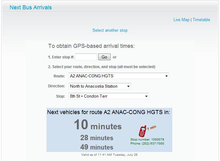
But in addition to the eye candy you have a full featured GPS bus tracking system.  For example, if you want to know when the next bus is going to arrive a certain stop all you need to do enter the number in box #1.  Or, if you don’t really know your stop number but you know your route, the direction you are traveling, and the stop you want to catch the bus at you just enter this information and you will get the next three estimated arrival times (as seen in the darker blue box).  Not the distances the bus is from the stop, but a real estimated time until the bus will reach that stop.  This is very useful information.

You will also notice that there is a little phone icon in this dark blue box.  This has a phone number to call in addition to the route and stop number code for your convenience.  How this works is that if you dial the number listed and then enter the route and stop code provided you will with the estimated arrival times.  This is great for people who have a little ways to walk before reaching their bus stop or who will be without computer access for a while but still want to use the bus to get home.

NextBus Bus Tracking GPS System Google MapAnother great feature available on the NextBus GPS tracking bus route system is that it also offer a GoogleMap-like interface for you to see where buses are on a route and when they might be.  It also lets user click on a stop and get the next three estimated arrival times for buses on that route.  This is a very cool feature for users.

I’m not very sure that there are any things that should be added to or improved upon this bus GPS tracking software, but I don’t know how accurate the time predictions are or how usable the system is on a cellular phone.  If this works just as well on a mobile phone as it does on a computer then this system is really neat.

Usability and Which Tracking System Has It

Which one would you rather use?  I know for certain that the NextBus system is more useful than the Where is My Bus? system.  Both are GPS tracking software packages that that give bus riders direct access to this GPS information gathered by these buses, but they do so in very different styles.  The style I like the best is definitely NextBus.  Its maps and time estimates make it much more user friendly and actually caters to how people think about catching the bus.

I mean no one is going to be able to instantly look at a bus being .4 miles away and go, “Okay, the bus is .4 miles away.  A bus traveling on a city street goes about .1 mile every 2 minutes at optimal driving conditions.  But today there is a little bit of traffic that I estimate will make it 20% slower.  I should get to the bus stop no later than 9 minutes from now just to play it safe.”  That is way too much math in public.

While the Where is My Bus? system is a good starting point for development, it is not even in the same league as the NextBus system in terms of usability.

But as a city administrator I would much rather go with the open source version that was cheaper to develop but offers less functionality.  Chris Willey, Washington’s interim CTO, put it this way, “We built it intentionally open so somebody else could make it better.  If you want to find out when is the next bus, we left it open for the community to figure that out. It’s really about creating a community of developers who are creating applications for government.” While this may not give certain people warm fuzzies all over it is sound thinking and wise decision making.

Knowing that a bus is .4 miles away is still useful information – it is just not as useful as know that it will be getting to the stop in about 8 minutes.

Final Analysis<

In the end, I am glad that government entities and private companies are taking up the call to provide useful GPS tracking systems for the common good.  Buses, trains, and trolleys can all benefit from the use of GPS devices.  It is just a shame that the cost to do so is $3 million (the cost of the NextBus GPS bus tracking system).  There needs to be a cheaper, open source solution if governments are going to be able to implement this functionality for all citizens on all lines of public transportation.  That is why the Where is My Bus? tracking system is so interesting – it holds out the hope for a free GPS tracking system for municipalities and states all across the nation and the world.

How To Create Your Very Own GPS Tracking System For Your Car

Creating your very own GPS system for cars is really a lot easier than you think.  In days long past you would to have had a hell of a lot of technical experience, a great understanding of how to create software, and a lot of money to get something like real-time GPS tracking to work for yourself.  You would have had to buy a ton of equipment that you would never normally use and spend countless hours coding software and making firmaware so that your devices could interact with your software.  This process would be both time and money intensive and very few of us would be able to get through it.

Today, it is a totally different story.  All you need to create an awesome, real-time GPS tracking system for your car is a navigational GPS that has bluetooth capabilities and a cell phone that can run a free GPS tracking application called 3dtracking.  It will also help to have a good cell phone plan with your provider that has plenty of data sending capabilities.  That is it.

The Equipment Needed

The GPS

The very first thing that you are going to need is going to be a GPS navigation unit.  This is because the 3dtracking software must have access to coordinates generated by a GPS device in order to provide real-time GPS tracking information.  Without some form of GPS information to feed your cell phone that is loaded up with this free GPS tracking software you are not going to be able to get yoru desired results.

While I don’t personally have a navigational GPS, I have heard some good things about the following devices that have Bluetooth capabilities:

If these prices are still to high for you personally then you might want to consider trying to find a refurbished GPS.  A refurbished device can sometimes come at a very steep discount (from 20%-50% in some cases) and it should work just as well as a ‘new’ device.

In some cases you won’t even need to own a stand alone car navigation GPS for this system to work. If you own a phone with GPS tracking capabilities already installed into the phone then you don’t need to connect to an external GPS device via Bluetooth.  Everything that you are going to need is going to be inside the case of that cell phone.

The Cell Phone

3dtracking published a list of compatible cell phones for their system.  If you do not own one of these phones then you will not be able to use this system as I am describing it.  Here is a list of the cell phones that is currently compatible with this software:

  • Lenovo P930
  • LG KS10
  • Nokia 3230
  • Nokia 3250
  • Nokia 5320
  • Nokia 5500
  • Nokia 5700
  • Nokia 6110
  • Nokia 6120
  • Nokia 6121
  • Nokia 6210
  • Nokia 6220
  • Nokia 6260
  • Nokia 6290
  • Nokia 6600
  • Nokia 6620
  • Nokia 6630
  • Nokia 6670
  • Nokia 6680
  • Nokia 6681
  • Nokia 6682
  • Nokia 7610
  • Nokia E50
  • Nokia E51
  • Nokia E60
  • Nokia E61
  • Nokia E61i
  • Nokia E62
  • Nokia E63
  • Nokia E65
  • Nokia E66
  • Nokia E70
  • Nokia E71
  • Nokia E90
  • Nokia N70
  • Nokia N71
  • Nokia N72
  • Nokia N73
  • Nokia N75
  • Nokia N76
  • Nokia N77
  • Nokia N78
  • Nokia N79
  • Nokia N80
  • Nokia N81
  • Nokia N81 8GB
  • Nokia N82
  • Nokia N85
  • Nokia N90
  • Nokia N91
  • Nokia N92
  • Nokia N93
  • Nokia N93i
  • Nokia N95
  • Nokia N95 8GB
  • Nokia N96
  • Panasonic X700
  • Panasonic X800
  • Samsung SGH-D720
  • Samsung SGH-D730
  • Samsung SGH-i400
  • Samsung SGH-i520
  • Samsung SGH-Z600

(Be sure to check the compatible cell phone list over at 3dtracking’s website in case this list has become out of date)

Some of these phones are rather inexpensive (some can be found for under $20) while others will cost over $200.  Which phone you choose will depend largely on your needs for the cell phone and whether or not you want to use it for more than just GPS tracking.

Once you have one of these phones you are going to want to make sure that you have a good data plan for your phone.  This way you can send data to the 3dtracking servers without incurring exorbitant fees.  Right now, AT&T wireless is offering a unlimited data plan for its phones for $35 a month.  This would put your access to real-time GPS tracking information for your car at roughly $1.17 per day.

3dtracking software

In order to download the free 3dtracking software simply go here.  There are onpage instructions for what to do depending on whether or not you have a Windows-based PDA or a smart phone.  Once you have downloaded the application and installed it on your phone or PDA you will do a brief 3 step application process and will be ready to begin tracking with your cell phone right away.

Total Cost to You

The startup cost of this GPS tracking system for cars can be pretty steep, coming in at over $400 if you buy some of the higher end equipment.  With a $35 unlimited data plan that would bring the first year total out of pocket expense to somewhere between $800 and $900.  The second year of operation would be $420.  While this certainly isn’t cheap, if you already have the GPS navigation unit and the compatible cell phone you won’t need to spend any money out of pocket so your expense will probably be $0 unless you have to upgrade the data plan on your phone to handle the load.  Free GPS tracking is certainly better than not free GPS tracking.

What Will You Track?

From where I sit there are two main applications for this type of GPS tracking system for cars.  They are tracking a teen driver and snooping on a spouse suspected of cheating.  For the former you should be completely up front and honest with your teen about what you are doing to their phone and why you are doing it.  They should know that you are concerned about their safety and that you want to make their driving experience as safe as possible.  Then you should work on some sensible rewards and punishments for your teen drivers.  Making sure they they buy into your GPS tracking system is key if it is going to be useful to them and to you.

IF you are tracking a spouse that you suspect of cheating you should not let them know that you are tracking them.  To do this, you might have to buy a special phone that you put in their car for them so that they don’t realize what is going on.  You will have to leave the phone on and recharge the battery often, but the ability to know if they are cheating or not can certainly be worth the price.

But this set-up, especially one where your phone has GPS capabilities built in, can be used in many more applicaitons.  A few of them are to:

There are practically as many things that you can do with this technology as you can dream up, so sit down, grab a beer, and dream.  This GPS tracking system for cars is definitely going to blow your mind if you let it.

Free GPS Tracking Applications and Software

You can get GPS tracking for free. There are a couple of different ways to get real-time tracking for your family, friends, or co-workers, but the vast majority of them have something to do with cell phones. Below is a list of several different free GPS tracking services that you can take a look at and decide which one is going to work best for you and your family.  Not all these free applications are available on all mobile devices, so be sure to look at the specific application’s compatible device list to see if your cell phone can run this free GPS tracking software.

InstaMapper – Cell Phone Tracking Made Simple

InstaMapper is a free cell phone tracking application available for download and installation on a cell phone. Getting an account is free and only takes a minute or two (be sure to have a valid email address ready for the registration process). After registering you will install an application on your cell phone that is going to provide all the tracking data. This application, when running, will periodically send the phone’s GPS coordinates to InstaMapper servers where they will compile the data for your own use.

Once your GPS coordinates are there, you can login to your account and see your location on an interactive Google map. This can be great for finding your way around a new place or figuring out exactly how to get someplace (this does require that your cell phone have internet access).  Also, if you want your family or friends to know where you are you can give them the login credentials to your account or you can embed a map of your location on a web property (such as a web page, blog, or Facebook profile). Alternatively, you could send them a link that will take them to a map on the InstaMapper website that will look like this.

This free application also lets you record 100,000 locations per mobile phone, organizing them into different tracks and exported in a variety of formats. This volume of locations is equivalent to several months of 24/7 tracking! Now that is a lot from a completely free GPS tracking application.

This is a very powerful application for anyone looking to let other know about their position in the world. Here is a list of compatible phones for this application.

If you are interested in this option, you should really consider looking at to get one of the many Boost Mobile cell phones that are compatible with these devices. According to the InstaMapper website, data plans can run as little as $0.35 per day, which comes out to around $11 per month, making it one of the most economical GPS tracking devices ever – and with an anticipated battery life of 8-12 hours this has many different potential uses for people and for companies.

If you are going be using this cell phone GPS tracking to monitor a teen driver, to check up on a cheating spouse, to monitor workers while they operate company vehicles, or just to get a better picture of where you have been or are at in the world then InstaMapper should be a very strong candidate for your GPS tracking needs.

3dtracking – Bringing GPS Tracking To PDAs

3dtracking is another application that can be downloaded for cell phones that can provide real-time GPS tracking, but unlike the InstaMapper application this is also available on a range of PDAs. For devices that are compatible with this software see their list of compatible devices.

Being an application compatible with PDAs, it lets you integrate a GPS device that you already own (like an automobile navigation unit like a Garmin Nuvi 760) with a web-enabled or cell phone PDA.  This can be extremely useful for those that already own these devices and who want to take advantage of one of the many free GPS tracking apps out there.

Here is a mock-up combination of devices from the 3dtracking website:

A possible example of a set-up for using 3dtracking is a Windows Pocket PC device (such as an Ipaq) that is used with a GPS receiver (Bluetooth or wired). The application will obtain the GPS data from the receiver and then transmit it back to our servers (if your device is both a phone and a PDA (e.g. the i-Mate/Qtek range of products) then it can connect via GPRS. If not, you can transmit all your data to our servers when you sync your PDA to your computer). Once on our servers, you can log in at any time to see your traveled route on either Google Earth or Google Maps. Just select your starting date and time, as well as your end date and time, and our systems will show you exactly where traveled and your speeds along the way.

You can make this data available to other people in a similar fashion to InstaMapper: you can give someone the login credentials to your account or you can put a map on a web property that you own.  However, it does appear that in order to put your map up on a website you must be able to edit information in the <head> html section of the webpage.  This is not possible on websites like Facebook, MySpace, or WordPress.com.  It is possible on Blogger, a self hosted WordPress blog, or a static html page that you might create.

In the end, this is an adequate system if you already have one of the devices mentioned on the list – but if you are just starting out and don’t own a device yet you might want to give InstaMapper a shot if you want to share your position data with someone else.

Mologogo – A Free Social Cell Phone Tracking GPS

Mologogo is like the Facebook of free GPS tracking applications for cell phones.  You can access the location of yourself or your friends from your phone or the web, giving you a quick picture of where everyone is at any given moment of the day.  This is great for people who are constantly on the go and love to keep their friends close.  You can get alerts when people on your friends list are close to you, or you can search to see if your friends are around a certain point of interest (like the club you are at), and stay updated with local weather and traffic conditions all from the same screen. Mologogo also lets its users engage in mobile chat, so you don’t need to burn up text messages if you don’t have an unlimited plan but want to have a quick conversation with a friend in your area.

Mologogo also lets you interact with all this data from a PC.  You can get a picture of where your friends are at at that very moment, you can add new friends to your account, and you can even show your location on your own webpage or blog (just like InstaMapper and 3dtracking).  Your ability to engage with others via your position information with this free cell phone tracking application is pretty phenomenal and offers something that neither of the two previously mentioned applications are able to provide as easily.  This is definitely the most social of all the GPS tracking apps I have seen.

If you want to know if your phone is compatible with this application then you should take a look at the following compatible phone list.  What this list essentially includes is any Nextel, Sprint, or Boost Mobile phones that is able to support Java and also has a GPS receiver installed. Mologogo is also able to be used on Blackberries, Windows Mobile Pocket PC Phones, and SmartPhones on any mobile provider as long as there is an external or internal GPS with the device.

The social aspect of Mologogo is really the best thing about it.  If you want to use your cell phone as a GPS tracking device for the purpose of connecting with your friends then there is no better application on the market.  But it does lack some of the useful features that make InstaMapper such a good application for a wide range of applications.  You simply cannot go wrong with Mologogo if you just want to stay connected to your friends.

LiveTracker – A Blackberry GPS Tracking App In Beta

LiveTracker is currently in beta development and is only available for Blackberry devices. It is still free, so users of the Blackberry should definitely consider using this free software on their phones.  One main perk is that you don’t need to register an account to use this software – all you do is download the software from the SkyLab website and install it on your phone. Start running the application and it will begin recording and sending your location coordinates that it gathered via GPS to the LiveTracker servers.

The ability to share locations with this app is still a little limited – you can only send tracking links via EMail, PIN, SMS, and MMS. You cannot currently embed your location like you can with all the other free GPS tracking applications already mentioned. While this is not that big of a deal for some users, embedding is very important to some users. However, since this software is still in beta you have to realize that these are probably features that the developers are planning on implementing at some point.

If you use a Blackberry you still might want to check this out if you are just trying to dabble in what cell phone GPS can provide.  It might not be as cool, powerful, or full featured as InstaMapper, 3dtracking, or Mologogo – but just because it isn’t now doesn’t mean that one day it might be the best app out there.

GeoTrack24 – Free (Limited) GPS Tracking For Phones and Devices

GeoTrack24 offers a free GPS tracking service, but the “free-ness” of this service is rather limited.  A free account will allow you to track one device, allow 1 person to be able to view this data, and has a history of 3 days.  There appears to be no way to share data with others, making it very hard to use this service for very much.  What does make this service unique is that it can be used on a wide range of devices – both cell phones and various GPS tracking devices.  For a full list of compatible devices see their cell phone list and units list.

Because you can use some GPS tracking devices with this service it is something that you might want to consider using, but the limited device history and 1 account makes it severely limited in what it can do.  They do offer some subscription based plans that are relatively inexpensive (rates are quoted in Pounds), but when you can get a similar, but better, service for free on a cell phone from another software package then you should probably consider this service last on your list.

If you just want to do some minimal free GPS cell phone tracking then this software is probably going to be good enough for you.  However, you should definitely consider some of the other applications mentioned here since they offer a higher quality service.

OpenGTS – Consumer Grade Free GPS Fleet Tracking Software

OpenGTS is a free GPS tracking software that is commercial grade.  Its main application is to be used in GPS fleet tracking, but it could be used to help a family monitor the activity of several people or vehicles at the same exact time.  This free software also differs greatly from some of the other applications mentioned above in that it is a server side tracking software – meaning that it is not installed on any device but is instead installed on a computer.   OpenGTS acts like the captain of your GPS tracking device, taking in the information that the device transmits via GPRS.

If you are looking for a short right up of this service you can read more about it at OpenGTS: A Free GPS Fleet Tracking Software.

GolfLogix – Free GPS Tracking Software For Golf Enthusiasts

If you are in the market for a free golf GPS tracking software then you have to check out GolfLogix.  They offer a a free golf GPS application for iPhones and Blackberries.  They don’t currently have a free app for all the different styles of Blackberry, so head on over to their site at GolfLogix to see if your particular flavor is able to run their software.  If you are a Verizon customer, you might be out of luck since this carrier is notorious for not letting people install third party applications on their Blackberries.

If you are looking to get free GPS tracking then you are probably going to be looking to the cell phone.  The number of free and useful applications available on these devices makes it a very compelling pick for those interested in getting GPS information in real time to a wide range of interested parties.

Do you have any experience with these free GPS cell phone tracking applications?  We would love to hear about them in the comments section below.

Covert GPS Tracking: A Short Story

“Blue Dodger, this is Home Base.  Do you read me!? Over.”  The radio gives a slight crackle as the voice of Home Base abruptly ends with a click.  You slowly touch the radio button on your vest and respond to Home Base, “Home Base, this is Blue Dodger.  I copy.  Over.”  You feel a slight tickle of excitement course through your veins as you await the message.  You know that Home Base is going to be giving you something good.   You have installed a covert GPS tracking device on a target vehicle and Home Base is going to be giving you the coordinates for you to track it down and discover what they are up to.

“Blue Dodger, we have the vehicle parked outside 13141 West Palm Avenue.  Head on over and report back your findings.”  This is your very first covert op and you feel a surge of adrenaline wash over you like a shore breaking wave, smoothly rattling the content of your chest.  The drive to the location isn’t long and you soon find yourself on a normally quiet residential street with cars lined up bumper to bumper on both sides of the street.  You find the 1995 Teal Corolla that you attached your covert GPS tracking device to parked exactly where Home Base said it was, but the car is empty.

“Home Base, this is Blue Dodger.  I’ve found the vehicle, but its clean.  I’ll park and see if I can get a visual. Over.”

“That’s a Roger, Blue Dodger.  Report in when you have a visual.”

You get out of the car and park.  Your palms begin to sweet as you slowly walk through the lamp lit street, keeping a low profile while trying to observe as much as you can.  As you make your way back to the Corolla you notice the sound of loud, thumping music coming from the other end of the street.  Without any sign of activity at 13141 West Palm Avenue you make your way toward the music.

As you draw closer you begin to hear the din of voices, laughing and the steady thumping of base.  It looks like the driver of the Corolla may be at this party.  Unfortunately, you don’t have your party threads on and the age of the crowd is significantly below your own – but you press on anyway knowing that you need to find the driver of the Corolla before it is too late.  You radio back to Home Base, “This is Blue Dodger, I’m going in.”

The music inside the house is deafening and it is all you can do to hug a wall and work your way around the interior of the house.  There is no communication with Home Base now.  You scan the crowd looking for the driver you were tracking but they are nowhere to be found.  Then, all of a sudden, you see in the other room a the long blond hair of the driver you have been trying to covertly track.  She is standing talking to a man several years her elder, his face stubbled with  a healthy five o’clock shadow.

You make your move on the target.

But before you do, you need to create a diversion to get her away from Mr. Five O’Clock.  You pull out your trusty cell phone that has been relaying your position to Home Base via GPS.  You send a simple text message, using your full qwerty keyboard because that is how you roll, with the message,

create diversion. call target. test time

In just a moment you see Long Blond Hair reach into her bag and pull out a glowing, vibrating cell phone.  She looks up at Mr. Five O’Clock shadow and seems to say something.  He smiles and waves as she leaves the room.  She walks past you in a hurry, but you are still holding the wall tight and she doesn’t notice.  You had anticipated that since the room is dark except for the constant flashing of mutli-colored lights.

Long Blond Hair leaves the house at a run and is soon 50 feet away from the house when she puts the still glowing and vibrating cell phone to her ear.  “Hello,” her voice sounds strong and confident.  She pauses for just a second, then with an oune of frustration in her voice she says, “What do you want?  I’m watching a movie at Katie’s house.”  You walk up behind her and tap her on the shoulder.

She turns around with a sudden look of horror on her face.  “Dad,” she says with a little fear in her voice, “What are you doing here?”

“I think the question is, honey, what are you doing here?”

~~~

You don’t have to be a spy or a member of the FBI to be able to use covert GPS tracking.  With GPS in cell phones and other personal devices a parent, spouse, concerned citizen, or private investigator can track a wide aray of items or assets with GPS.  You can install GPS trackers in cars or use them to monitor a teen’s driving habits.

If you want to go with traditionally covert GPS devices then you are going to need to fork out some significant cash.  Round the clock monitoring and real-time tracking capabilities do not come cheap – so expect to shell out $100s just for the device itself.  Then you are also going to need to pay up for a service fee as well so you can get access to your tracking information.  You might be able to build your own system out of one of the open source GPS tracking devices that have skematics on the Internet, but then you need some high quality GPS tracking software as well to make sure that your data is getting stored and displayed properly.  There is open source software for this too, but you will have to trade some of your precious time to learn how to use it.

In the end analysis, almost anyone with enough money is going to have access to tracking with GPS – and you don’t even need that much money anymore to get some really cool, cover GPS tracking devices.