Running in the ‘Burbs
Endomondo proved more than capable of tracking my suburban runs by utilizing the GPS tracking functionality of my phone. In both of my runs, the there-and-back-again and suburban loop, I found that the distances were fairly accurate when compared to Google Maps, with accuracy being very high on the there-and-back-again run. The app can be off by as many at 10 m as you track the route, which on larger suburban loop runs can amount to a noticeable lengthening or shortening of the run, though in our tests the difference was not terribly significant. When compared with a Google Maps measurement we saw a .1 mile (10%) difference between what Endomondo recorded. This is simply an approximation since Google Maps does not give mileage to the hundredth place and measures streets as close to the middle as possible; the difference could conceivably be a little less or a little more..
Endomondo is recommended to track suburban running.
Suburban There and Back Run | Suburban Loop Run
Suburban There and Back Running
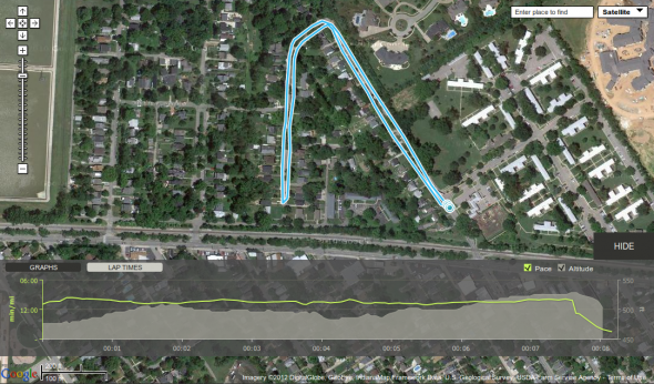
This run was taken on February 7 on a relatively cloudless sky. I did the run with my Galaxy Nexus running Endomondo Pro and the phone was inside a Scosche armband. This run was performed barefoot while running with traffic on the street in a there and back pattern. According to the app I ran .81 miles. Google Maps puts the run at .8 miles. This difference is really no difference at all. My start and stop points are practically perfect. They are off by maybe 10 ft according to measurements taken by Google Maps’ Distance Measurement Tool.
What is interesting is that the route appears to be off by as many as 10 m (about 30 ft) from the actual path that I ran. Again, these distances were measured using Google Maps.
The stats graph showed a steady pace and a relatively steady altitude changes. The one problem that surfaced was that the start and end spot of the run were essentially at the same point on the street, just on opposite sides of it. Yet the elevation difference is just at 25 ft (7.6 m). This is impossible. It doesn’t bother me, but it could if you are craving EXACT location data for the run.
Loop Run
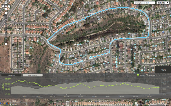
This run was taken on Jan 9 on a bright and sunny day. I was using my Droid X running Endomondo Pro and the phone was in my hand. The run took me through the treacherous suburban landscape where my bare feet had to navigate hundreds of pebbles. Luckily, I made it through until the end. On this run I stopped when Endomondo told me that I had run a mile, but my official Endomondo run registered as 1.01 miles. I ran in the street the entire time just to the left of parked cars. The same route measured with Google Maps was 1.1 miles. I forgot to check my exact start and stop spots for comparison on this run, but they do seem accurate to me.
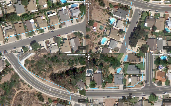
The question is, where did the extra .1 mile go? I think this image might have something to do with it:
The GPS tracking on the app had me running through front yards, off into the canyon, and even through one person’s home (click on the image if you need to see a larger version). This cut off a significant amount of path measured by Google Maps, which always measured the route in the street. Google Maps probably measured the route long since the placement of the lines appear to be as close to the center of the street as possible. The difference between the two routes is probably like the difference between two people running that same lap on a traditional track where one person runs in the inside lane while the other runs in the outside lane. The person on the outside will always run a longer lap than the person on the inside will, even though they both run one lap.
The altitude changes on this run appear pretty accurate given the course we ran. Our beginning and ending measurements were approximately 10 ft apart (333 ft at the beginning and 344 ft at the end), which is essentially meaningless since there probably was a slight difference in start and end altitude. The changes in altitude as the run progressed also match the actual flow of the course, with the exception that the changes are smoother than the graph seems to represent.
Review Home | Track Tests | Suburban Tests | Nature Tests | Indoor Tests | How To Use


